Showing posts sorted by relevance for query Smoking Gun. Sort by date Show all posts

Friday, April 29, 2016

Smoking Gun

An impressive book provides smoking gun evidence to help us resolve the Book of Mormon New World correlation conundrum.
Smoking Gun: Scientific Evidence Highly
Favoring a Particular Theory

Shutterstock Licensed Image
The book is entitled Fiery Pool: The Maya and the Mythic Sea. It was co-published in 2010 by Peabody Essex Museum (PEM) and Yale University Press. Editors are Daniel Finamore of PEM and Stephen D. Houston of Brown University. Houston was on the BYU Anthropology Faculty for a number of years earlier in his career. Like David Stuart, he is a Macarthur Fellow, recipient of a so-called "genius grant."
Significant Book on the Maya and the Sea
The book accompanied a major museum exhibition displayed at PEM (Salem, MA) and the Kimbell Art Museum (Fort Worth, TX) in 2010 followed by the Saint Louis Art Museum (St. Louis, MO) in 2011. Contributors to the volume are a veritable who's who of contemporary Maya scholars. Pieces in the exhibit came from major museums in Europe and the Americas. Page numbers in this article refer to Fiery Pool unless otherwise indicated.

No place in the ancient Maya world was more than 260 kilometers (160 miles) from the open ocean.
Circle with 258 Kilometer Radius
The sea was a much larger presence in daily life and thought among the Maya than has heretofore been recognized. Fiery Pool was revisionist - it precipitated a revolution of sorts in our understanding of the Maya marine worldview (p. 6).

The sea loomed large in the daily life and thought of the Nephites. This list ranks various ecological features by the number of verses in the text that mention them. Features where at least some of the passages refer to the sea are highlighted in yellow.
  • 212 wilderness
  • 123 water & waters
  • 81 sea
  • 68 borders
  • 43 mountain
  • 41 river
  • 36 valley
  • 34 hill
  • 30 depths
  • 24 seashore
  • 19 mount
  • 13 forest
  • 11 isle & isles
  • 9 waves
  • 8 deep (as a noun)
  • 8 plain (as a noun)
  • 3 islands
  • 3 thicket
  • 2 shore
  • 2 whale
  • 2 grass
  • 1 beach
  • 1 grove
This smoking gun evidence says Book of Mormon lands are in a location - such as Mesoamerica - where the culture exhibits strong maritime influence.
--
The Maya believed some of their ancestors originally came from across the sea (p. 15). The Book of Mormon chronicles 3 migrations that originally came from across the sea 1 Nephi 18:23, Omni 1:15,
Ether 6:12.

In their Popol Vuh, the K'iche' Maya say that their ancestors came from "across the sea." K'iche' scholar Allen Christenson believes the sea they refer to may be the Bay of Chetumal which matches the geography of their legendary migration route.
--
The Maya believed they were surrounded by the sea (p. 15). Mormon wrote that the land southward was nearly surrounded by water Alma 22:32. If you trace the coastline and land bridges of the land mass east of the Coatzacoalcos and west of the Ulua (rougthly the area inside the circle on the map below) 88% of the littoral is salt water ocean and 12% is dry land.
Maya Area Nearly Surrounded by Water
This smoking gun evidence says Book of Mormon lands are in a place - such as Mesoamerica - where most horizons look seaward.
--
The Maya conceived of the earth as a turtle or crocodile floating on the sea (pp. 210-112).
Kaminaljuyu Sculpture 2, the Earth Crocodile
Drawings by Lucia Henderson
The Book of Mormon peoples envisioned themselves inhabiting an isle of the sea 2 Nephi 10:21.

This smoking gun evidence says Book of Mormon lands are in a watery environment - such as Mesoamerica - with coastal characteristics.
--
The Maya identified four seas, one in each of the four cardinal directions (pp. 15, 204, 212-213).
The Nephites identified four seas, one in each of the four cardinal directions Helaman 3:8.
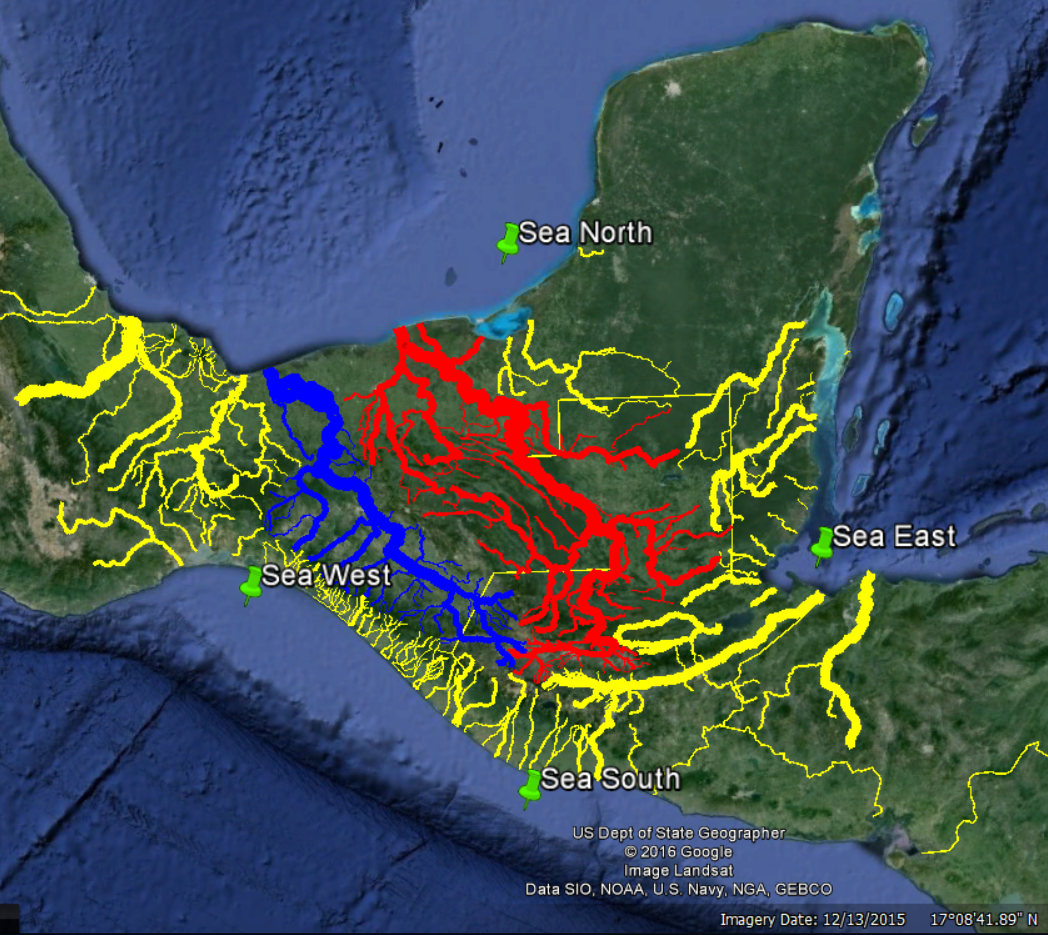
Seas North, South, East & West According to the
January, 2016 Book of Mormon Lands Map
This smoking gun evidence contradicts those who interpret some of the seas in Helaman 3:8 as metaphorical rather than actual bodies of water. For more on bodies of water in each of the four cardinal directions, see the article "Quichean Directionality."
--
Now things get really interesting. The Maya and other ancient Mesoamericans were unequivocal in their identification of the east sea - it was the Caribbean along the coasts of Guatemala, Belize, and Quintana Roo - the sea from which the sun rises. This is the sea called the fiery pool because of its solar association.This is the sea whose color was red, the eastern color. This is the sea that symbolized fertility and abundance because the Maya believed rain came from the east (pp. 204, 212, 214-215).

This smoking gun evidence favors maps by Ric Hauck, Joe and Blake Allen, Shelby Saberon, Elder Clate Mask, Jr., and Kirk Magleby (this blog), all of whom correlate the east sea with the Caribbean. It casts serious doubt on maps by Garth Norman and Aric Turner, both of whom wrap the east sea up around the Yucatan Peninsula and down into the Gulf of Mexico. It all but eliminates John Sorenson's model which correlates the east sea with the western portion of the Gulf of Mexico.

See the article "Maya Place Names" for 3 other Book of Mormon toponyms ("the east by the seashore" of Alma 22:29; "the river" of Alma 43:52, and "bountiful" of Alma 53:3) that now have an ancient Maya counterpart.
--
The Maya viewed the world as divided into four quarters oriented to the cardinal and intercardinal points (pp. 204, 212-213).
Cardinal and Intercardinal Points
Here are three Maya depictions of this quadripartite concept from Fiery Pool p. 213.
Earth Turtles Divided into Four Quarters
From left to right, these images are from the Book of the Chilam Balam of Chumayel, Mayapan, and Kaminaljuyu. All drawings by Karl A. Taube.

The Book of Mormon mentions quarters of the land fourteen times e.g. Alma 52:10.

This smoking gun evidence favors maps by Ric Hauck, Joe and Blake Allen, Aric Turner, Garth Norman, Shelby Saberon, Elder Clate Mask, Jr., and Kirk Magleby (this blog), all of whom correlate the directions north, south, east and west in the Book of Mormon with the solar-derived cardinal directions. It repudiates John Sorenson's much-maligned attempt to skew the cardinal directions. In the words of Mark Wright, an accomplished Mesoamericanist on the BYU Religion Faculty, "Rio Azul Tomb 12 is determinant." His mentor, Karl Taube, in Fiery Pool agrees (p. 204). Rio Azul Tomb 12 on its four walls displays the Maya glyphs for the four directions all in their correct orientation. Corroborating information is found on Copan Stela A and the Yotz Kanpet ceramic bowl rim text.
--
Article by Kirk Magleby who volunteers as Executive Director of Book of Mormon Central, world's premiere source of reliable Book of Mormon contextual material in English and Spanish.

Article updated January 22, 2018

Saturday, July 16, 2016

Four Sides, Four Quarters, and a Center

The Book of Mormon describes its world as having four sides aligned with the four cardinal directions Mosiah 27:6, 3 Nephi 1:17. It also describes its world as having four quarters Alma 43:26, Alma 52:10. The Nephites described their focal point as the heart Helaman 1:18 or center Helaman 1:25-27 of their land. Furthermore, they perceived themselves inhabiting a single isle of the sea 2 Nephi 10:20-21 nearly surrounded by water Alma 22:32 with salt water on every side Helaman 3:8. For more context see the blog articles "Test #5 North South East and West" and "Smoking Gun."
For examples of the widespread Mesoamerican notion of a spatial quincunx, see the article "Light from LA" points 6 and 43.

A beautiful portrayal of this worldview was found at Masada where a replica hangs in the Visitor Center.
Replica of Mosaic, Masada, Israel Photo by Kirk Magleby June 20, 2016
This wall hanging shows four sides, four quarters, and a center all surrounded by water.

Corresponding depictions are found throughout the Americas. This is a museum replica of the well-known Inca Chakana.
Chakana from Museo Larco, Lima, Peru in Kirk Magleby's Collection
A very similar version of this symbol is on the Lanzon at the Temple of Chavin. It is attested in Andean art from Chavin  through Inca times (2nd millennium BC - European contact).

The same idea is expressed on the striking Hopewell Wheel displayed in the Ohio History Connection Museum in Columbus.
Hopewell Copper Wheel First Millennium AD
As we would expect, this worldview was widely portrayed throughout Mesoamerica. This is a pre-columbian representation thought to have originated in Veracruz.
Codex Fejervary-Mayer now in the World Museum, Liverpool, England

Wednesday, May 29, 2019

The River

The Book of Mormon mentions only one river, the Sidon, by name, and it is referenced more than 25 times (e.g. Alma 3:3). Almost all references call it "the river Sidon" (e.g. Alma 6:7). There is one reference, though, where Mormon called the Sidon simply "the river" (Alma 43:52). All of these conditions (uniquely named, frequently mentioned, generically named), point to a singular river that dominated its landscape. Most contemporary Book of Mormon modelers (myself included) correlate the Sidon with the mighty Usumacinta, the largest river in Mesoamerica.
Main Channel of the Chixoy, Salinas, and Usumacinta
I recently found confirmation that the Chontal Maya called the Usumacinta Xocolha which can simply mean "the river." Ronald L. Canter, "Rivers Among the Ruins: The Usumacinta" in PARI Journal, Vol. VII, No. 3, Winter 2007.

This is the third geographic reference in the Nephite text where we have a precise correlate in Mayan. The other two are the "east sea" (see the blog article "Smoking Gun") and "the east" (see the blog article "Maya Place Names"). 

Saturday, February 8, 2020

Cacaxtla

I spent Wednesday, January 29, 2020 at the site of Cacaxtla, Tlaxcala with my friends, Javier Tovar, Ignacio Salguero, and Alejandro Martinez.
Tovar, Magleby, and Salguero at Cacaxtla
We filmed a video in Spanish that establishes the case for Mesoamerica being the land where New World Book of Mormon events took place from twenty different perspectives. Cacaxtla is renowned for its vibrant murals and for the fact that it is essentially a Maya site in the heart of central Mexico. Three things are interesting about the site right off the bat:
  1. The first settlers of Cacaxtla showed up ca. AD 400 just after the Nephites were exterminated and while Moroni was wandering during his solitary last 35 years of life. Cacaxtla reached apogee AD 600 - 900.
  2. Later historians called these first settlers the "Ulmeca Xicalanca" and archaeologically we know many of them came from the Gulf Coast of Tabasco and Campeche. The Book of Mormon describes large migrations beginning ca. 55 BC from the land southward into the land northward Alma 63:6, 7 and those migrations continued to the end of the record Mormon 2:28, 29.
  3. The site of Xicalango, Campeche, is 685 air kilometers distant, 800 kilometers if you follow Mexican Highways 150 and 180. We know from archaelology that Cacaxtla and Xicalango maintained a strong trade and cultural relationship in middle to late classic times. This distance is in the ballpark of the size most serious students of the text deduce for Nephite lands (1,000 - 1,200 air kilometers maximum extent of terra cognita).
Cacaxtla's sister site 1 kilometer away, Xochitecatl, was occupied ca. 800 BC and abandoned ca. AD 150 after Popocatépetl erupted yet again. Popocatépetl (5,426 meters or 17,802 feet) and Ixtaccíhuatl (5,230 meters or 17,159 feet) are the second and third highest peaks in Mexico (after Orizaba's 5,636 meters or 18,491 feet) and these two impressive volcanos dominate Cacaxtla's horizon.
Aerial View of Ixtaccíhuatl in Foreground, Popocatépetl in Background
Cacaxtla in context:
Cacaxtla Maintained Trade and Cultural Relationships
with Maya Sites Hundreds of Kilometers Distant
This was my third trip to Cacaxtla over the years. During that time INAH has made significant improvements to the site including the addition of an excellent small museum. From a Book of Mormon perspective, these are the things at Cacaxtla that caught my attention.

1. Mormon 4:14-15, 21 talks about the Lamanites sacrificing Nephite children. At Cacaxtla excavations revealed more than 200 sacrificed children buried as an offering during construction of the Palace. As with all images on this blog, click to enlarge.
Sacrificed Children Interred in the Cacaxtla Palace 
2. It is clear from the text that the Book of Mormon peoples were very aware of the surrounding oceans. See the blog article "Smoking Gun." Even though it is more than 200 kilometers from the nearest salt water, Cacaxtla preserves ample evidence of a marine mindset.
Marine Shells on Display, Cacaxtla Museum
Marine creatures are on the bottom of this Jaguar-themed mural.
Aquatic Animals Depicted on Cacaxtla Mural
3. The text describes mountains that move and respond as animate beings (Jacob 4:6; Alma 12:14; Helaman 10:9; 12:9-10, 17; Mormon 8:24; Ether 12:30). Ancient Mesoamericans viewed mountains as living beings, particularly big volcanoes such as Popocatépetl and Ixtaccíhuatl that breathed smoke, emitted rumblings, and occasionally erupted.
Representations of the Two Volcanoes Near Cacaxtla
The Mixtec Codex Vindobonensis Mexicanus I (14th century AD) describes mountains as living beings.
  Placard in the Cacaxtla Museum Referencing Codex Vindobonensis
4. The Book of Mormon mentions shields as part of a warrior's protective armor (Alma 43:19, 21; 44:9; 46:13; 49:6, 24; Helaman 1:14; 3 Nephi 3:26; Ether 15:15. 24). Cacaxtla has several war murals which all depict elaborately decorated shields.
Cacaxtla War Mural Depicting Various Types of Shields
The Nahuatl name for shield is chimalli.
Placard in the Cacaxtla Museum Referencing Chimalli (Shields)
Spanish (Escudos)
5. The Book of Mormon mentions spears (Alma 17:7) and javelins (Jarom 1:8, Alma 51:34, 62:36) as offensive weapons. Several murals show spears or lances.
Cacaxtla War Mural Showing Spears or Lances
Volcanic glass (obsidian) was fashioned into projectile points.
Obsidian Lance Points
6. The Book of Mormon twice lists grains important to the Nephite diet (Mosiah 7:22; 9:9). In both cases, corn appears first on the list. Corn was clearly a staple crop among Book of Mormon peoples (Mosiah 9:14). Corn was the principal food crop grown throughout ancient Mesoamerica and Cacaxtla has numerous depictions of it.
Ears of Corn in Ceramic, Cacaxtla Museum
Corn figures prominently in the famous Cacaxtla murals.
Ripe Corn with Silks
Corn today is the most important food crop on the planet, generating more agricultural income than rice, wheat, or any other staple. Consequently, corn has been intensively studied and its origins are widely-known. It was domesticated in central Mexico ca. 6,000 BC. By 5,000 BC it had spread throughout Mesoamerica and the Andes. It was then carried to the American Southwest (Arizona, New Mexico) ca. 2,100 BC and finally began entering the Mississippi River Basin ca. AD 100. Widespread corn (zea mays) cultivation in the Mississippi drainage and points east began ca. AD 900, enabling the rise of Cahokia, the first true city in the region.

How do we know these dates? The Canadian Archaeological Radiocarbon Database (CARD) contains tens of thousands of C14 dates from all over the world. The University of British Columbia has created a subset of CARD they call the Ancient Maize Map. This map visualizes hundreds of macro samples (corn cobs) and micro samples (corn pollen, phytoliths) from the Americas which have been competently radiocarbon dated.
University of British Columbia Ancient Maize Map
An exhibit on display in the Ohio History Connection Museum in Columbus validates this data. Isolated corn kernels have been found in Hopewell (ca. 100 BC - AD 500) mounds, but widespread corn cultivation and consumption in Ohio did not begin until centuries after the Hopewell.
Display in Ohio History Center Museum
The absence of corn during Book of Mormon times is a fatal flaw in any model that attempts to locate Nephite and Jaredite lands. Corn is the only grain grown widely enough in ancient America to supply the caloric needs of the populations (Ether 15:2 says millions) mentioned in the text. I am indebted to BYU's prolific Mesoamericanist, Kerry Hull, for this profound insight. The first true city in what is today the USA was Cahokia in East Saint Louis, IL. Cahokia's population at apogee (AD 1050 - 1200) reached 20,000. It was the arrival of widespread maize agriculture in the area around Cahokia that allowed the urbanization to coalesce. No corn, no city.

Mesoamerica, on the other hand, had extensive and intensive corn cultivation since early Jaredite times.
Ears of Corn from a Carved Stone Panel in the
National Museum of Anthropology, Mexico City
7. The Book of Mormon contains the curious idea that a human and a plant can co-exist in the same physical body, that people can become trees (Alma 32:28, 41). We see anthropomorphic plants among the luxuriant Cacaxtla murals.
Human Heads as Ears of Corn on a Cornstalk
8. The Book of Mormon says people in the land northward used cement as an architectural building material (Helaman 3:7, 9, 11). Cacaxtla is in the part of Mesoamerica most Book of Mormon modelers consider the land northward. Major public structures at Cacaxtla were built using cement.
Elaborately Worked Cement Pillar at Cacaxtla
9. The Book of Mormon says the Nephites reaised flocks and herds and animals of every kind 2 Nephi 5:11. That may have included birds such as the South Mexican wild turkey Meleagris gallopavo gallopavo which has been found in a preclassic context at El Mirador in Guatemala's Peten. The Palace at Cacaxtla had a room dedicated to aviculture.
Cacaxtla Room with Bird Cages (Jaulas)
10. The Book of Mormon associates Jesus Christ with both a bird and a serpent. The bird serpent imagery comes from the incident where fiery flying serpents were biting and killing the Israelites in the wilderness 1 Nephi 17:41, Numbers 21:6. Moses was instructed to create a metallic serpent and lift it up on a pole. Whoever was bitten by the poisonous serpents and looked upon the brazen serpent was instantly healed 2 Nephi 25:20, Numbers 21:8,9. The serpent on a pole, of course, was a symbol of the Savior on the cross John 3:14.
Moses Raising the Brazen Serpent in the Wilderness
The Book of Mormon mentions or alludes to the brazen serpent incident and its attendant avian imagery several times. The raised or lifted serpent motif is more prominent in the Book of Mormon than in the Bible:

  • 1 Nephi 11:33 The Savior at His crucifixion would be lifted up.
  • 1 Nephi 17:41 the fiery serpents could fly, combining avian & reptilian characteristics.
  • 1 Nephi 19:10 The Savior at His crucifixion would be lifted up.
  • 2 Nephi 25:13 After the crucifixion, the Savior would resurrect with healing in his wings.
  • 2 Nephi 25:20 Moses raised up the brazen (bronze) serpent. The act of raising up symbolizes flight or ascension to heaven.
  • Alma 33:19 The serpent Moses raised up in the wilderness was a type of the Savior.
  • Helaman 8:14, 15 The brazen serpent lifted up by Moses symbolized life through Christ.
  • 3 Nephi 10:4-6 The Savior compared Himself to a hen gathering chickens under her wings.
  • 3 Nephi 25:2 The Savior would arise with healing in his wings.
  • 3 Nephi 27:14-15 The Savior was sent to earth to be lifted up on the cross and draw all men unto Him.
  • 3 Nephi 28:6 Jesus Christ was lifted up by the Jews.
  • Ether 4:1 The Savior would be lifted up upon the cross.
It may be that bird serpent imagery is prevalent in the Book of Mormon because a Mesoamerican belief in a feathered serpent was common and the Nephites were trying to liken the scriptures unto themselves. This is a feathered serpent image from La Venta Monument 19 which dates to ca. 600 BC.
Serpent with Feathers on La Venta Monument 19 in the
National Museum of Anthropology, Mexico City
Parenthetically, many have commented over the years how the bucket-like object in the anthropomorphic figure's right hand is similar to objects depicted on Assyrian bas relief panels from Nimrud. This panel is from Ashurnasirpal II's palace. He reigned from 883 - 859 BC.
Bucket-like Object in Anthropomorphic Figure's Left Hand
Assyrian Relief in the Bowdoin College Museum of Art
 And this is a feathered serpent image from Teotihuacan which dates to ca. AD 300.
Serpent Scepter with Feathers in the Site Museum, Teotihuacan
The Mesoamerican feathered serpent is strongly correlated with the pan-Mesoamerican deity Quetzalcoatl. Quetzal in Nahuatl means "precious feathers" alluding to the famous Quetzal bird from the cloud forests of Guatemala. Coatl in Nahuatl means "serpent." This is one of several represenations of Quetzalcoatl from Cacaxtla. This mural dates to ca. AD 700.
Cacaxtla Priest or Ruler Representing Quetzalcoatl
This personage has prominent wings at his shoulders and he holds a serpent bar as a symbol of power. He has bird feet and he is standing on a feathered serpent. This is a close-up of the feathered serpent from the replica mural in the site museum.
Cacaxtla Feathered Serpent with a Beard
Several of the murals at Cacaxtla have a similar feathered serpent around their border.

11. One last small item. The Book of Mormon mentions sounding a trumpet (3 Nephi 13:2, Ether 14:28). An artifact from Cacaxtla shows a figure blowing on a conch shell trumpet.
Sounding a Trumpet, Cacaxtla Museum
Cacaxtla is a terrific site, well worth a visit.

Kirk Magleby volunteers as Executive Director of Book of Mormon Central which builds enduring faith in Jesus Christ by making the Book of Mormon accessible, comprehensible, and defensible to the entire world. Book of Mormon Central publishes the remarkable new scripture study app ScripturePlus.

Wednesday, January 18, 2017

Tracking the Jaredites

The Jaredite saga began at the Tower of Babel Ether 1:33. Biblical tradition has long held that the Tower of Babel was in the land of Shinar based on Genesis 10:10 and Genesis 11:2. Shinar is generally associated with Babylon in the alluvial plain between the lower Tigris and Euphrates. See Bible Dictionary Shinar, Plain of. From Babel, the Brother of Jared was instructed to lead his small band northward down into the Valley of Nimrod Ether 1:42, Ether 2:1.

One problem locating the Tower of Babel near Babylon is that virtually all topography northward is up in elevation and the Book of Mormon explicitly says they went down. In 2011, Anne Habermehl published a revisionist article entitled "Where in the World is the Tower of Babel?" She argues that Shinar was in the Khabur triangle of northern Mesopotamia in the  NE corner of modern Syria. From Habermehl's Babel one can in fact go northward and drop down in elevation.
Anne Habermehl's Proposed Tower of Babel Location
From the Valley of Nimrod, the group went into "that quarter where there never had man been" Ether 2:5. Since their eventual destination was an ocean leading to the New World, they must have gone either east to the Pacific or west to the Atlantic. John L. Sorenson in 1985 (An Ancient American Setting for the Book of Mormon) suggested they traveled east to the Pacific and landed on the west coast of Mexico. In 2013 (Mormon's Codex: An Ancient American Book) Sorenson changed his mind and postulated an Atlantic crossing disembarking in Veracruz. I find Sorenson's 1985 model more convincing. His 2013 reversal is based on several assumptions I find problematic:
  1. Textual indications that the Jaredites incorporated pre-existing populations into their polities favor a Veracruz setting. This is not necessarily true. There is as much evidence for pre-Jaredite peoples in Guerrero, Central Mexico, Puebla, and Oaxaca as there is in Veracruz.
  2. Sorenson places Heth approximately at modern Xalapa, Moron at Cordoba, and Nehor at Tuxtepec. He then says Moron was in the southern tier of Jaredite lands which contradicts his map. He further says Moron was near Nephite Desolation which also contradicts his map. Finally he says that Moron was up in elevation relative to other Jaredite lands, a condition required by the text Ether 7:5, 14:11 but not obvious on his map.
  3. Because Sorenson correlates the Nephite narrow pass Alma 50:34, 52:9, Mormon 3:5 with the "Tehuantepec Ridge" between Minatitlan and Acayucan, he tries to cluster Jaredite lands in the same general vicinity. His east west "gravelly ridge" has never made any sense to me. I have yet to find it on any topo map. Several north south "ridges" bisect it, defeating its supposed purpose. I have been in the area and inquired locally to no avail. The natives I have spoken with do not acknowledge any such natural feature. I believe the narrow pass identified in the Book of Mormon Lands Map 2016 on the Pacific coast of Chiapas is a more likely candidate and a stronger fit to the text. See the article entitled "The Narrow Pass and Narrow Passage."
  4. The severe drought mentioned in Ether 9:30 is more likely in arid Oaxaca or Puebla than in humid Veracruz.
  5. Sorenson's insistence that Ether 9:3 and 14:26 both refer to the "east sea" are probably forced readings. The text simply says people went eastward to a sea. The Gulf of Campeche, Sorenson's "east sea" is NW or even WNW of both his Zarahemla (Santa Rosa) and his Nephi (Kaminaljuyu). We now know that the ancient Maya called the Caribbean the "east sea." See the article entitled "Smoking Gun."
  6. Sorenson's point that no single river in south central Veracruz stands out is simply wrong. The Papaloapan is by far the largest river in this part of Mexico.
  7. Sorenson correlates the Jaredites with the Olmec who had influence from Central Mexico to the Caribbean and from the Gulf of Mexico to the Pacific.
Sorenson's proposed Jaredite lands (yellow pins) overlay a map of sites with known Olmec influence.
Olmec World (Orange) with Sorenson's Jaredites (Yellow)
I have difficulty reconciling Ether 1:43 and the extensive Olmec world with Sorenson's diminutive Jaredite territory.

I share the view more common among LDS Mesoamericanists that the Jaredites landed on the west coast of Mexico and spread first throughout the land northward. Upland Oaxaca is a suitable candidate for the land of Moron.

David Rosenvall, one of the brightest contemporary Book of Mormon theorists, suggests that the Jaredites left the Tower of Babel area and turned eastward, building barges to cross the large inland Caspian Sea Ether 2:6-7.
Proposed Jaredite Route Eastward to Inland Sea
From there he thinks they traveled across Central Asia and China to the highest mountain on the Chinese coast - 1,083 meter Mount Laoshan Ether 3:1.
Proposed Jaredite Routes Eastward to Mount Shelem
Mount Laoshan is interesting because it is the traditional birthplace of both Taoism and Chinese culture generally. From Mount Laoshan the mythological Eight Immortals crossed the sea.
Eight Immortals Crossing the Sea
Relief from Qingsong Temple, Hong Kong
One of the eight, Zhongli Quan, reputedly had the power to turn stones into silver and gold.

From Mount Shelem, eight Jaredite barges were blown across the ocean for 344 days Ether 6:11 until they reached the New World. This is  a detail we can test scientifically.

On March 11, 2011 a massive tsunami killed 16,000 people in northern Japan and washed millions of tons of debris into the ocean. On December 13, 2011 buoys from Japan reached Vancouver Island, British Columbia, the first objects from the tsunami to cross the Pacific.
Buoys from Japan retrieved from a Canadian Beach
Light enough to be blown by the wind Ether 6:8, the buoys drifted for 276 days. Two days later, December 15, 2011, the first tsunami debris landed on Washington's Olympic Peninsula after drifting for 278 days. Similar Japanese buoys from oyster farms began appearing on beaches in the Alaska Panhandle in January, 2012. The first vessel to arrive, the Japanese shrimping boat Ryou-Un Maru from Hokkaido, was spotted in Canadian waters off British Columbia on March 23, 2012. It was adrift as a ghost ship for 377 days. It was scuttled to avoid damaging other vessels. A few days later a Harley Davidson motorcycle in a shipping container landed on Graham Island, British Columbia. Its Japanese owner donated it to the Harley Davidson Museum in Milwaukee.

So, we have recent credible evidence that drifting waterborne objects from northern Japan can reach North American shores in a period of 276 - 377 days. Assuming the Jaredites crossed the North Pacific, this tsunami drift data supports the Book of Mormon account to a remarkable degree. This is a map of the places Japanese tsunami debris had landed as of March, 2016, five years after the disaster.
Japanese Tsunami Drift Map
According to the University of Hawaii International Pacific Research Center IPRC Drift Model, the Book of Mormon's 344 days is right in the sweet spot of probability for northern Pacific oceanic passage of objects that ride high enough in the water to catch the wind which the Jaredite barges clearly did.

Sunday, April 28, 2019

Komkom Vase

A shattered royal drinking vessel discovered in 2015 at Baking Pot, Belize bears a long Mayan inscription that originally consisted of 202 glyph blocks, about 60% of which are extant after reconstruction.
Komkom Vase Dedicated AD 812 
Baking Pot is on the Belize River.
Baking Pot, Belize in Context
A critical text of this important inscription was recently published - Christophe Helmke, Julie A. Hoggarth, Jaime J. Awe, A Reading of the Komkom Vase Discovered at Baking Pot, Belize (San Francisco: Precolumbia Mesoweb Press, 2018) 144 pp. Helmke is at the University of Copenhagen, Hoggarth at Baylor, and Awe at Northern Arizona. The fact that they published a critical text only 3 years after the vase's discovery is a credit to the authors and a result of the remarkable worldwide collaboration among contemporary Mayanists.

The vessel was owned by the king of Komkom, an unidentified site probably on the Belize River and allied with the more powerful Naranjo to the west. Buenavista del Cayo is an increasingly likely candidate for Komkom. The text was copied from an earlier historical record, almost certainly painted on bark paper. The text on Naranjo Stela 12, dedicated AD 800, ultimately derives from that same earlier historical source. Naranjo Stela 12 and the Komkom vase describe the same military engagements with Yaxha and Tikal, but from the different perspectives of Naranjo and its junior partner, Komkom. The military action took place between February and September, AD 799.

The Komkom vase text has a number of interesting similarities with the much earlier Book of Mormon.
  • Komkom p. 22 The vase text has calendrical, historical narrative, and parentage components. The Book of Mormon establishes chronology, recites historical narrative, and declares lineage relationships Alma 63:15-17. Another example of this calendrical, historical, genealogical sequence is Tortuguero Monument 6. See Sven Gronemeyer and Barbara MacLeod, Wayeb Notes No. 34, 2010.
  • Komkom p. 30 cites our friend, Kerry Hull of the BYU religion faculty, because the vase text uses the elegant poetic form difrasismo or "diphrastic kenning" where dual extremes imply a larger whole. Hull has pointed out several examples of this poetic form in the Nephite record including 2 Nephi 10:16, 2 Nephi 26:33, and Alma 11:44. Komkom p. 39 says difrasismo has endured virtually unchanged as a poetic form in Mayan literature for two millenia.
  • Komkom p. 32 describes the title "five headdresses" applied to elite women. The phrase is known from inscriptions at half a dozen Maya sites.
This is Linda Schele's drawing of the Palace Tablet, Palenque.
K'inich K'an Joy Chitam Flanked by his Parents
All three figures wear elaborate headdresses. Lady Tz'akbu Ajaw to the right is wearing at least three headdresses. K'inich Janaab Pakal to the left is holding a headdress.

These are Linda Schele's drawings of various headdresses:
Headdresses from Palenque, Machaquila, Yaxchilan, and Piedras Negras
The Book of Mormon calls tall headdresses "high heads." 2 Nephi 28:14 talks about prideful people who wear stiff necks and high heads. Jacob 2:13 explicitly says prideful people wear stiff necks and high heads because they can afford costly apparel. Some Mesoamerican headdresses were so heavy and cumbersome the wearers used a back rack with a vertical pole or lattice to hold everything up. Back racks with vertical support may be the "stiff necks" Nephi and Jacob refer to.
  • Komkom p. 34 analyzes the linguistics of the title "eastern 28 chief" attested from the sites of Dos Pilas, Machaquila, Ixkun, Naranjo, and Caracol. All of these sites where the term has been found (now including Baking Pot) are in the central (Usumacinta) or eastern (Maya Mountains) sector of the Maya world. This is precisely where many Book of Mormon modelers place "the east wilderness" mentioned in Alma chapters 25 and 50 and "the east by the seashore" in Alma 22:29. The "eastern 28" part of the Maya title is likely a late Classic regional grouping of polities.
This  map shows sites where the title "eastern 28 chief" is found, the Maya Mountains in brown overlay, and plausible correlates for the Book of Mormon "east."
Sites where "East" is Attested with Possible Book of Mormon Correlates
The blockbuster discovery that the Book of Mormon "east sea" may now be corroborated in ancient Mayan inscriptions is discussed in the 2016 article "Smoking Gun." More information about the region the Maya considered "the east" is in the 2018 article "Maya Place Names." Alexandre Tokovinine, author of the very important 2013 monograph Place and Identity in Classic Maya Narratives and world's leading expert on Maya toponyms, really likes the new Helmke, Hoggarth, Awe, Komkom Vase book per his favorable Amazon review.
  • Komkom p. 36-37 The Mayan verb ch'ahb describes a devotional act such as fasting or doing penance. The meaning "let blood" originally proposed in Linda Schele's era is no longer considered viable. The Book of Mormon mentions fasting in a devotional context dozens of times, e.g. Alma 45:1, Helaman 3:35.
  • Komkom p. 41 describes a military campaign in AD 696 where enemy structures were set ablaze. The Book of Mormon describes a military campaign ca. AD 379 where villages and towns were burned with fire Mormon 5:5. Komkom p. 56 describes another burning of an opponent's home town in a martial context. Komkom pp. 70, 75 mention yet others. 
  • Komkom p. 42-43 cites Mayan texts that describe Motul de San Jose and Yaxha as being west of Naranjo and the Baking Pot area as east of it.
This map shows the four sites generally in a west-east alignment.
Motul & Yaxha West of Naranjo, Baking Pot East of It
The late Classic Maya used a system of solar-based directional cardinality similar to our own. Their meaning of "west" and "east" nearly matched our modern usage of those terms.

  • Komkom p. 50 says particular forests had names in the Maya world. The Book of Mormon has a named forest Mosiah 18:30.
  • Komkom p. 51 talks about a conquering army scattering the bones of an enemy king. The Book of Mormon mentions scattered bones Omni 1:22.
  • Komkom p. 52 mentions the construction of paved roads in AD 588. The Book of Mormon describes the construction of paved roads ca. AD 29 3 Nephi 6:8. Komkom p. 62 talks about "four-breadth roadways," a term found also at Naranjo and Caracol. Maya highway widths were classified by standard units of measure. The Book of Mormon implies different sized roadways when it mentions both "roads" and "highways" in 3 Nephi 6:8.
  • Komkom p. 52 cites the phrase "it is set in order" which recalls the wording of Alma 8:1 where Alma "established the order" of the church in Gideon.
  • Komkom p. 52 says the sociopolitical relationship between the site of Naranjo and some of its neighbors was stable for 220 years. The Book of Mormon describes similar periods of stability Jarom 1:5.
  • Komkom p. 53 describes kab which is the Mayan word for "bee." Ether 2:3 describes the Jaredite word for "honey bee."
  • KomKom p. 55 note 18 says the term "large waters" used throughout Mesoamerica refers to a river. This may have significant implications for Book of Mormon geography. The terms "waters of Sidon" and "river Sidon" are used interchangeably in the text Alma 43:40. Alma baptized in the waters of Sidon Alma 4:4 just like his father had baptized in the waters of Mormon Mosiah 25:18. The waters of Mormon may be a river just like the waters of Sidon are a river. Ditto the waters of Sebus Alma 19:20-21 and the waters of Ripliancum which are explicitly called "large" Ether 15:8.
  • Komkom p. 58 says the sites of Yaxha (Yaxa'), Mopan (Monpaan), Motul (Mutu'l), and Laguna la Blanca (Sakha') carry names that have remained largely unchanged since late Classic times. It is well known in historical linguistic circles that toponyms are remarkably resistant to change. This gives us hope that more Book of Mormon toponyms (in addition to "east sea" and "the east" discussed above) may be found as Maya decipherment advances.
  • Komkom p. 62 describes a regal title translated as "he of nine lands." The most prominent political organization mentioned in the Nephite text is "land" and some rulers had dominion over multiple lands Alma 22:1.
  • Komkom p. 64 outlines a chiastic structure. The Book of Mormon contains dozens of chiastic structures such as Mosiah 5:10-12.
  • Komkom p. 65 discusses deity impersonation where a human donned regalia and acted like a particular god. The Mayan phrase for this behavior is rendered "it is his/her image in the state of being like a god." Alma alluded to this practice when he asked his followers in the city of Zarahemla if they had received the image of God engraved in their countenance Alma 5:14,19.
  • Komkom p. 66 talks about a captured king who was killed with a torch. In the Book of Mormon, King Noah suffered death by fire Mosiah 19:20.
  • Komkom p. 71 tells about a king who ascended a mountain to evade military pressure. The Book of Mormon tells a similar story about Lehonti atop Mount Antipas Alma 47:10. Komkom p. 86 discusses the idea of people fleeing and taking refuge in an elevated place. This is exactly what happened when Mosiah 1 led the Nephites from the land of Nephi down to the land of Zarahemla. The large group took temporary refuge en route on the hill north of Shilom Mosiah 11:13.
  • Komkom p. 73 describes the practice of giving a youth a different name after he matured and began to fulfill his adult role in society. Paranomasia (pun names) are one implementation that Matthew Bowen has found throughout the Book of Mormon. See his "Name as Key-Word, Collected Essays on Onomastic Wordplay."
  • Komkom p. 74 discusses the Mayan adverb uhtiiy which means "it happened." The Book of Mormon variant is the ubiquitous "It came to pass" e.g. Alma 47:2-3.
  • Komkom p. 76 says the ancient Maya measured distance by a day's walk. The Book of Mormon peoples measured distance by a day's journey Alma 8:6.
  • Komkom p. 82 says many localities mentioned in ancient Mayan texts cannot be identified on the modern map. It should not surprise us that many localities mentioned in the Book of Mormon have not yet been identified on the modern map.
  • Komkom p. 84 talks about historical annals, records kept year by year. Large parts of the Book of Mormon such as Helaman 11:21-24 are abridgments from historical annals.