My wife, Shannon, and I took our summer holiday this year in France. It was her seventh or eighth trip to the place, my second (she teaches high school French). We traveled for 17 days in a grand circle around the periphery of the country, celebrating our 37th wedding anniversary on the Riviera. Dining on bread, cheese and produce from farmer's markets was a treat. Wandering around the Clos Luce manor house in Amboise where Leonardo da Vinci spent the last three years of his life was sublime. A number of things we saw helped me understand the Book of Mormon in a more intimate and profound way.
1. Rivers determine interior settlement patterns, the confluence of 2 streams creates a special place, and upstream from the delta + downstream from the head of navigation is a highly favorable location. As a country is being settled, important cities tend to be built on major rivers or good harbors. In France, The #1 city, Paris, is on the Seine at an elevation of approximately 60 meters 165 air kilometers from the mouth. The #2 city, Marseille, has a good port near the mouth of the Rhone. The #3 city, Lyon, lies at the confluence of the Saone and the Rhone at an elevation of about 180 meters 270 air kilometers from the mouth of the Rhone. The #4 city, Toulouse, is on the Garonne at an elevation of about 150 meters 297 air kilometers from the mouth. The #5 city, Nice, has a spectacular port. The #6 city, Nantes, is on the Loire at an elevation of about 12 meters 48 air kilometers from the mouth. The #7 city, Strasbourg, a major river port, is located at the confluence of the Ill and the Rhine at an elevation of about 140 meters 450 air kilometers from the mouth of the Rhine. The #8 city, Montpellier, is on the Lez at an elevation of about 55 meters 11 air kilometers from the mouth. The #9 city, Bordeaux, is on the Garonne, near its confluence with the Dordogne, at an elevation of about 20 meters 93 air kilometers from the mouth of the Garonne. And the #10 city, Lille, is on the Deule at an elevation of about 35 meters 96 air kilometers from the mouth. These 10 cities have a mean elevation of approximately 65 meters and lie at a mean distance of 143 meters from the coast. France is a nation (not counting overseas dependencies) with 551,500 square meters of surface area and 3,427 kilometers of coastline on 3 major bodies of water (English Channel, Atlantic, Mediterranean). It's highest point, Mont Blanc, has an elevation of 4,810 meters.
 |
| 10 Most Populous Cities in France, with Elevations |
2. At the same time the Mulekites (likely with Phoenician help) were settling Zarahemla, the Greeks were settling southern France. Massalia (modern Marseille), founded in 600 BC., is the oldest city in France. Nibley, quoting Karl Jaspers, calls the 6th century BC the "axial period" of world history (
An Approach to the Book of Mormon, Preface to the Second Edition, Salt Lake City: Deseret Book, 1964). At that very moment, the Greeks and Phoenicians were competing to colonize vast stretches of Mediterranean and Black Sea coastlines. This map shows where they planted colonies. Blue = Greek and red = Phoenician.
 |
Greek (blue) and Phoenician (red) colonies around the Mediterranean
and Black Seas, ca. 550 B.C. |
Note where these ancient peoples settled. Except for the country of Greece itself and a single exception in the Nile delta, all Phoenician and Greek territories ca. 550 B.C. were within 20 - 30 kilometers of the coast.
2a. Greek coastal settlements in southern France (and NE Spain) during the 6th century BC. represented with blue placemarks.
 |
Eight Greek settlements in southern France and
north eastern Spain during the sixth century BC |
2b. During the Roman era, settlements expanded throughout much of ancient Gaul. Administrative centers were established to exploit natural resources and control trade. This map shows major Roman settlements represented with red placemarks.
 |
| Major Roman centers in ancient Gaul |
Tongeren is near the Geer which flows into the Maastricht canal system. Metz is at the confluence of the Moselle and the Seille. Autun is on the Arroux, tributary of the Loire. Vaison-la-Romaine, Orange, Glanum, Nimes and Arles are all part of the lower Rhone system. Narbonne anciently was a port on the Aude, until the river changed course, landlocking the city.
3. The Egyptian Hall in the Louvre has a display of weights and measures. Rather than coins, the Egyptians used weights of metals and grains as stores of value and media of exchange.
 |
| Egyptian weights used for commercial transactions on display in the Louvre |
This exhibit text explains the Egyptian system of commercial interchange based on commodity values.
 |
| Louvre exhibit text referencing weights of metals and grains |
4. Ancient France had many walled cities. The walls surrounding Aigues-Mortes have a perimeter 1.63 kilometers long, enclosing an area of 16.2 hectares (.162 square kilometers). The population inside the city walls probably never exceeded 1,500 which would have been a population density of approximately 9,260 per square kilometer.
 |
| The modern city of Aigues-Mortes inside a medieval wall |
The walls surrounding Carcassonne have a perimeter 1.28 kilometers long, enclosing an area of 9.7 hectares (.097 square kilometers). The population inside the city walls probably never exceeded 1,200 which would have been a population density of approximately 12,370 per square kilometer).
 |
| Carcassonne wall & moat |
4a. The Emperor Augustus ordered a wall built around the city of Nimes ca. 15 B.C. It was roughly in the shape of a circle with a diameter of about 1.91 kilometers and a circumference of nearly 6 kilometers, enclosing approximately 286 hectares (2.86 square kilometers) of surface area.The famous tour Magne in Nimes is a remnant of this ancient wall.
 |
| Tour Magne in Nimes, ruin of city wall built about the time of Christ |
Population estimates for Nimes during Roman times run as high as 60,000. The city's coliseum seated about 20,000.
 |
| Roman Coliseum, Nimes |
Could 60,000 people have lived within the Nimes city wall? That would have been an ancient population density of 20,979 per square kilometer, about on par with modern Karachi, Pakistan. The excavated Roman city Pompeii had a population density of approximately 18,000 per square kilometer. Rome's port, Ostia, had an estimated population density of 32,000 per square kilometer, about the same as modern Mumbai (Bombay) in India. J.E. Stambaugh,
The Ancient Roman City, Baltimore: John Hopkins University Press, 1988. So, 60,000 living within the city wall of ancient Nimes is a plausible number.
5. Nimes ca. 15 BC was home to many veterans of Julius Ceasar's Nile campaigns who were given land grants in the area after 15 years of service in the legion. These retired Roman military men adopted a distinctive symbol for their new city - a crocodile chained to a palm tree representing their victory in Egypt. This is a Roman coin from the era of the Emperor Augustus.
 |
| Augustinian Coin |
This is a representation of the Nimes emblem one sees frequently in the modern city.
 |
| Crocodile chained to a palm tree |
And this is a modern, stylized version.
 |
| Nimes municipal symbol |
6. On the north coast of Brittany lies the picturesque walled port city Saint-Malo, home to the notorious corsairs (privateers, pirates) that preyed on Spanish and British shipping. Even though Saint-Malo was a thorn in their neighbor's side for centuries, the town never fell to enemy action. Many other ports along the French coast were captured by the British from time to time, but never Saint-Malo which maintained a certain autonomy even among other Bretons. What was the secret to Saint-Malo's incredible defenses? While most cities in France were built of limestone, Saint-Malo was built of much harder granite found along that part of the Breton coast. It was not until the high explosive aerial bombardments of World War II that Saint-Malo's granite ramparts were breached. You won't find the gothic splendor of Notre Dame or Chartres in Saint-Malo. Granite is much too hard to work for filigree or extensive statuary. What you will find are massive fortifications that stood for centuries against the most powerful military force on earth at the time.
 |
| Granite defensive walls of Saint-Malo |
--
So, what do these French observations have to do with the Book of Mormon?
1. Rivers determined settlement patterns in Mesoamerica. The Olmec and their successors tended to locate major cities on rivers. The confluence of 2 streams and the headwaters of 2 streams (continental divide) created strategic areas. The coastal plain upstream from the flood-prone delta but downstream from the head of navigation (fall line) was highly favorable for settlement.Plotting the largest ancient population centers in the area occupied by the Jaredites, Mulekites, Nephites and Lamanites, we find San Lorenzo on the Coatzacoalcos at an elevation of approximately 20 meters 58 air kilometers from the mouth. La Venta was anciently at the confluence of the Tonala with the Mezcalapa-Grijalva (see the article "
Wandering River" in this blog) at an elevation of approximately 30 meters 15 air kilometers from the mouth of the Mezcalapa-Grijalva. Comalcalco was also anciently on the Mezcalapa-Grijalva (after it shifted course - see the article "
Wandering River" referenced above) at an elevation of approximately 12 meters 18 air kilometers from the mouth. Palenque was built between the headwaters of the Chacamay which flowed eastward to the Usumacinta and the Michol which flowed westward to the Chilapa and eventually to the Usumacinta at an elevation of approximately 150 meters 141 air kilometers from the mouth of the Usumacinta. Piedras Negras was on the Usumacinta at an elevation of approximately 130 meters 220 air kilometers from the mouth. Its rival, Yaxchilan, was in an oxbow bend of the Usumacinta at an elevation of approximately160 meters 262 air kilometers from the mouth. Kaminaljuyu was located strategically on the continental, divide between the La Canada flowing to the Pacific and the Platanos, tributary of the Motagua flowing to the Caribbean at an elevation of approximately 1,540 meters 80 air kilometers from the mouth of the La Canada. Copan was on the Copan, tributary of the Rio Grande de Zacapa, which itself is a tributary of the Motagua at an elevation of approximately 600 meters 137 air kilometers from the mouth of the Motagua. Caracol was on a tributary of the Ceibo Grande which itself is tributary to the Belize at an elevation of approximately 525 meters 127 air kilometers from the mouth of the Belize. Tikal was situated on the continental divide between the headwaters of the Rio Azul - Rio Hondo which forms the border between Mexico and Belize and the headwaters of the San Pedro, major tributary of the Usumacinta, at an elevation of approximately 310 meters 197 air kilometers from the mouth of the Rio Azul - Rio Hondo at Chetumal Bay. Nakbe, on the other hand, was on the continental divide between the Candelaria drainage to the north and the San Pedro drainage to the south, at an elevation of approximately 290 meters 186 air kilometers from the mouth of the Candelaria at Laguna de Terminos. El Mirador was on a tributary of the Candelaria at an elevation of approximately 290 meters 174 air kilometers from the mouth. Calakmul was on another tributary of the Candelaria at an elevation of approximately 230 meters 167 air kilometers from the mouth. These 13 cities had a mean elevation of approximately 330 meters and were situated at a mean distance of 137 kilometers from the coast. Book of Mormon lands occupied approximately 387,730 square kilometers of surface area with 2,370 kilometers of coastline on 3 major bodies of water (Gulf of Mexico, Caribbean, Pacific). The highest point, Volcano Tajumulco in Guatemala, has an elevation of 4,220 meters.
 |
13 Most Populous Cities in Ancient Southern
Mesoamerica with Elevations |
1a. Plotting Nephite cities (and in a few instances, lands where no city is attested in the text) in the greater land of Zarahemla according to our correlation shows very similar results. Rivers determined settlement patterns among the Nephites who tended to build cities on rivers. The confluence of 2 streams and the headwaters between 2 streams were strategic areas. The area upstream from the delta but downstream from the head of navigation (fall line) was a favorable location. Note in the map below that not all correlated sites have labels. At this viewing altitude, some of the sites appear very close together, and Google Earth only renders one label to avoid superimposition. As with all images on this blog, click to enlarge.
 |
31 Proposed Book of Mormon Correlates with Elevations
Google Earth Has Rendered Labels for 28 |
On the map above, the Usumacinta (Sidon) system is in red, the Mezcalapa-Grijalva system is in blue and all other river systems are in yellow. We will analyze our Nephite Book of Mormon correlates by drainage which will permit more detailed closeup maps.
7 Pacific (Sea West) Sites
1a1. Villa del Mar (Teancum) was coastal, on the shores of Mar Muerto at an elevation of about 3 meters, flanked by the Lagartero & El Rosario Rivers.
1a2. Paredon (Desolation) was coastal, on the shores of Mar Muerto at an elevation of about 3 meters, flanked by the Tiltepec & Paredon Rivers.
1a3. Tzutzuculi (Jaredite Lib) was on the Zanatenco River at an elevation of about 45 meters, 13 air kilometers from the mouth.
1a4. Joaquin Amaro (representing the land of Joshua) was on the Espiritu Santo River at an elevation of about 8 meters 12 air kilometers from the mouth.
1a5. Pueblo Nuevo (Judea) was on the Cintalapa River at an elevation of about 20 meters 19 air kilometers from the mouth.
1a6. La Concepcion (City Beyond) was near the coast on the Cinlola River, tributary of the Vado Ancho, at an elevation of about 3 meters bordering a large estuary about 7 kilometers from the open sea.
1a7. Tuzantan (Antiparah) was on the Lazaro Cardenas River, tributary of the Zapaluto (also known as the Despoblado), at an elevation of about 445 meters 39 kilometers from the mouth. The site was also just north and west of our narrow strip of wilderness boundary between the greater lands of Zarahemla on the north and Nephi on the south.
 |
7 Candidate Book of Mormon Sites with Elevations
on Pacific (Sea West) Drainages Shown in Yellow |
2 Mezcalapa-Grijalva Sites
1a8. Amatenanco de la Frontera (Cumeni) was at the confluence of the Chimalapa with the Cuilco, just north of our narrow strip of wilderness (shown in green on the map below) at an elevation of about 1,000 meters 374 air kilometers from the mouth of the Mezcalapa-Grijalva (as it flowed in early Nephite times).
1a9. Tecpan (Zeezrom) was on the Selegua, just north of our narrow strip of wilderness at an elevation of about 2.020 meters 396 air kilometers from the mouth of the Mezcalapa-Grijalva (as it flowed in early Nephite times).
 |
2 Candidate Book of Mormon Sites with Elevations
on Tributaries of the Mezcalapa-Grijalva Shown in Blue |
11 Usumacinta Sites
1a10. Nueva Esperanza Calatraba (Zarahemla) was upstream from the permanent flood plain + downstream from the head of navigation on the Usumacinta at an elevation of about 40 meters 131 air kilometers from the mouth.
1a11. Balancan (representing the Most Capital Parts of the Land) was upstream from the permanent flood plain + downstream from the head of navigation on the Usumacinta at an elevation of about 11 meters 151 air kilometers from the mouth. In our correlation, the Most Capital Parts of the Land also included the confluence of the San Pedro with the Usumacinta.
1a12. Chinikiha (representing the land of Minon) was on the Chinquita, tributary of the Usumacinta, at an elevation of about 140 meters 180 air kilometers from the mouth of the Usumacinta.
1a13. Los Callejones (Gideon) was in a valley adjoining the Usumacinta at an elevation of about 190 meters 196 air kilometers from the mouth.
1a14. El Hormiguero II (Ammonihah) was at the confluence of the La Profundidad with the San Pedro, tributary of the Usumacinta, at an elevation of about 50 meters 240 air kilometers from the mouth of the Usumacinta.
1a15. Pie de Gallo (representing the land of Sidom) was on the Arroyo Pie de Gallo at the confluence of the Tamaris with the San Pedro, tributary of the Usumacinta, at an elevation of about 70 meters 288 air kilometers from the mouth of the Usumacinta.
1a16. Tornillo (representing the land of Melek) was on the Echeverria, tributary of the Usumacinta, at an elevation of about 115 meters 276 air kilometers from the mouth of the Usumacinta.
1a17. Itzan (Noah) was at the confluence of a minor tributary with the Pasion, tributary of the Usumacinta, at an elevation of about 150 meters 328 air kilometers from the mouth of the Usumacinta.
1a18. El Ceibal (Aaron) was at the confluence of the Riachuelo San Martin with the Pasion, tributary of the Usumacinta, inside a great bend of the Pasion, at an elevation of 220 meters 362 air kilometers from the mouth of the Usumacinta.
1a19. Cancuen (Nephihah) was on the Pasion, tributary of the Usumacinta, just downstream from the confluence of the Sebol with the Pasion, the point at which the Pasion becomes navigable (head of navigation). Cancuen was at an elevation of about 140 meters 402 air kilometers from the mouth of the Usumacinta.
1a20. Chama (Manti) was at the confluence of the Sachichaj with the Usumacinta at an elevation of about 305 meters 398 kilometers from the mouth of the Usumacinta.
 |
11 Candidate Book of Mormon Sites with Elevations
on the Usumacinta & its Tributaries Shown in Red |
10 Caribbean (Sea East) Sites
1a21. Bugambila (Bountiful) was coastal, on Chetumal Bay at the mouth of the Rio Azul - Rio Hondo that defines the modern border between Mexico on the north and Belize on the south. It sat at an elevation of about 8 meters.
1a22. Cerros (Mulek) was coastal, on an arm of Chetumal Bay at the mouth of the New River, at an elevation of about 10 meters.
1a23. Yakalche (Gid) was on Ernesto Creek, tributary of the Northern River, at an elevation of about 20 meters 13 air kilometers from the mouth of the Northern River.
1a24. Lamanai (representing the land of Jershon) was on the New River at an altitude of about 10 meters 70 air kilometers from the mouth.
1a25. Altun Ha (Omer) was between the headwaters of Santana Creek and a tributary of the Belize River at an altitude of about 20 meters 12 air kilometers from the mouth of Santana Creek.
1a26. Oshon (Morianton) was on the Sibun River at an elevation of about 14 meters 12 air kilometers from the mouth.
1a27. Esperanza (representing the land of Antionum) was at the confluence of the Mopan with the Belize River at an elevation of 95 meters 95 air kilometers from the mouth of the Belize.
1a28. Tzimin Kax (representing the land of Siron) was on a tributary of the Belize River at an elevation of about 655 meters 111 air kilometers from the mouth of the Belize.
1a29. False Cay (Lehi) was coastal, located at the mouth of Silver Creek where the stream enters the estuary behind Placentia Peninsula, at an elevation of about 10 meters.
1a30. Tiger Mound (Moroni), now underwater in the Bay of Amatique, was coastal, located at the mouth of the Rio Grande at an elevation presumed to have been near sea level.
 |
10 Candidate Book of Mormon Sites with Elevations
on Caribbean (Sea East) Drainages Shown in Yellow |
These 30 proposed Nephite locations had a mean elevation of about 194 meters and were situated at a mean distance of 134 kilometers from the mouths of their respective rivers.
Conclusion #1. As we study settlement in Roman France, modern France, ancient southern Mesoamerica and our proposed Book of Mormon territory, we find very similar patterns. In all cases, settlement followed rivers and the confluence of 2 streams created a strategic area. In Mesoamerica, the continental divide or the land between the headwaters of 2 or more streams created a strategic area. Coastal plains upstream from the delta but downstream from the head of navigation were prime settlement zones. In France and Book of Mormon lands, 20% of the cities analyzed were on the coast, so they had lower average elevations than the large Mesoamerican centers which were all inland. The fact that settlements in the 3 data sets averaged 143, 137 and 134 kilometers upstream from the mouths of their respective rivers is quite striking. This puts our Book of Mormon correlations squarely in the sweet spot of plausibility.
--
2. If the Mulekites employed the services of Phoenicians to cross the Atlantic in the sixth century B.C. as many Book of Mormon scholars suspect (e.g. John L. Sorenson,
Mormon's Codex: An Ancient American Book, Salt Lake City: Deseret Book & The Neal A. Maxwell Institute for Religious Scholarship, 2013, page 33) then Phoenician and Greek settlement patterns throughout the Mediterranean at this same time period could help us locate Zarahemla. In the Mediterranean, the sea-faring Greeks and Phoenicians founded coastal settlements except in the Nile Delta where they ventured some distance upstream and settled on the banks of the large, navigable river.
Helaman 6:10 tells us that Mulek settled in what would eventually become Nephite territory north of the narrow strip of wilderness.
Mosiah 25:2 adds that the land Mulek settled was a wilderness.
Words of Mormon 1:13 explicitly says the land of Nephi was at a higher elevation than the local land of Zarahemla. We learn in
Omni 1:13 and
Omni 1:27 that a great deal of wilderness lay between Nephi and Zarahemla, and this wilderness was at a higher elevation than Zarahemla.
Mosiah 7:4 is quite clear that the land of Nephi was at a higher elevation still. So, one went down from Nephi to the wilderness and down again from the wilderness to Zarahemla.
Omni 1:14 says the Nephites and Mulekites were unaware of each other's existence for more than 380 years before their joyous meeting ca. 200 B.C.In
Omni 1:16 we learn the Mulekites, after their ocean voyage, settled the local land of Zarahemla and remained in that same vicinity for centuries until Mosiah
1 arrived ca. 200 B.C.
Alma 22:30 explains that the Mulekites, after crossing the North Atlantic, made first landfall in the land northward at the place the Nephites later called Cumorah.
Alma 22:31 shows that the Mulekites, after leaving the beach near Hill Ramah-Cumorah, came up into a wilderness in the land southward and settled there permanently. This map illustrates our interpretation of Mulekite peregrinations.
 |
| Proposed Mulekite Migration |
The correlation shown above fits the Book of Mormon text precisely at all points. It is also consistent with the Greek & Phoenician settlement pattern known from the Old World in the sixth century B.C. The scenario we envision:
- Mulek and company made landfall at the mouth of the Papaloapan in southern Veracruz.
- After letting the sweet water remove barnacles from their hull and taking on fresh stores, they coasted around the Tuxtla Mountains.
- They stopped at the mouths of the Coatzacoalcos and Tonala/Mezcalapa-Grijalva, but found both places too densely populated for their purpose.
- Coming to the mouth of the Usumacinta, they were impressed with the huge volume of water it discharged into the sea. (The Spanish first saw the mouth of the Usumacinta on Juan de Grijalva's 1518 expedition. They were amazed to taste sweet water 15 - 20 kilometers out to sea.)
- Sailing up the Usumacinta, the Mulek party passed through a vast wilderness of wetlands and settled on the first high ground they found upstream from the permanent flood plain.
- From the mouth of the Usumacinta to our proposed city of Zarahemla, they had traveled 200 river kilometers (131 air kilometers) upstream and risen 40 meters in elevation.
- They were still 164 river kilometers (48 air kilometers) downstream from the head of navigation at Boca del Cerro.
Conclusion #2. Our location for Zarahemla, on the west bank of a large, north-flowing, navigable river fits comfortably with scriptural and ancient historical criteria.
--
3. The Nephite system of stored value and media of exchange was based on standardized weights of grains and metals
Alma 11:7.
Conclusion #3. The Louvre display of a similar Egyptian system lends credibility to the Nephite text. For a provocative discussion of the Nephite exchange system, see John W. Welch, "Weighing and Measuring in the Worlds of the Book of Mormon" in
Journal of Book of Mormon Studies Volume 8 Number 2 (1999) and John W. Welch "Ancient Parallels for Mosiah's System of Weights and Measures" in Donald W. Parry, Daniel C. Peterson & John W. Welch, editors,
Echoes and Evidences of the Book of Mormon, Provo: FARMS, 2002, pp. 348-350. Concise visuals of the Nephite and Egyptian systems are in John W. Welch and J. Gregory Welch,
Charting the Book of Mormon, Provo: FARMS, 1999, charts 110-113.
--
4. The Book of Mormon talks about walls and defensive fortifications around many cities.
Mosiah 9:8 describes the city of Nephi as walled.
Helaman 13:4 says the same for the city of Zarahemla.
Alma 53:4 mentions a formidable wall around the city of Bountiful.
Alma 50:1 references crude walls hastily erected around every urbanization in the entire Nephite domain.
For years, one of the criticisms Book of Mormon students had of the Kaminaljuyu/Nephi correlation was that no wall around Kaminaljuyu had ever been found. That has now changed. Japanese archaeologists in the early 1990's found remains of a very suitable wall. John L. Sorenson,
Mormon's Codex: An Ancient American Book, Salt Lake City: Deseret Book & Neal A. Maxwell Institute for Religious Scholarship, 2013, pp. 385-386.
Earthen walls tend to erode over time. Timber palisades deteriorate. Stone walls are often pillaged for building materials when a once powerful city goes into political and economic decline. So, the discovery of a wall around any ancient urban area in any part of the world is a fortuitous find for an archaeologist. Walls define boundaries and facilitate precise mapping. Walls that do get preserved through the ages become major tourist attractions (e.g. the great wall of China, Mont-Saint-Michel in Normandy).
As we look for the remains of walls around potential Book of Mormon cities, it would be useful to have a rule of thumb to correlate the length of a wall with the size of the population living inside, i.e. population density usually expressed in terms of people per square kilometer or people per hectare (1/100 of a square kilometer). Some modern referents (the 26 megacities with populations over 10 million) showing people per square kilometer according to the 2012 edition of
Demographia World Urban Atlas:
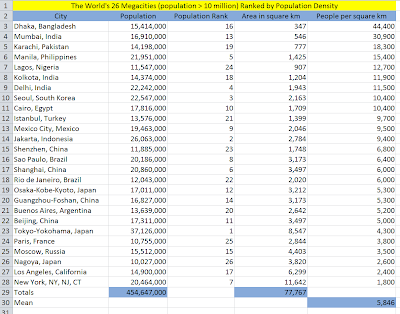 |
| World's Largest Cities Ranked by Population Density |
And, some ancient referents gathered from many sources including Noe V. Ilano's 1961 M.I.T. Master's Thesis entitled "A Survey of Population Density of Ancient, Medieval and Modern Cities in Relation to Transportation" and Paul F. Healy, Christopher G. B. Helmke, Jaime J. Awe, & Kay S. Sunahara, "Survey, Settlement and Population History at the Ancient Maya Site of Pacbitun, Belize" in
Journal of Field Archaeology, Volume 37, Number 1, Spring 2007:
 |
| Ancient Cities Ranked by Population Density |
In general, ancient Mesoamerican cities were far less densely populated than their Old World counterparts. Setting a high (5,000 people per square kilometer) medium (2,500 people per square kilometer) and low (750 per square kilometer) population density estimate allows us to build a crude area to population conversion table that shows the length of a city wall we would expect for a given population, or vice versa.
 |
| Estimated Areas and Populations within Mesoamerican City Walls |
Conclusion #4. If we were to discover a city wall 10 kilometers in length, it would have enclosed an area of approximately 800 hectares or 8 square kilometers and would have supported an ancient population of 6,000 to 40,000 depending on density. For an idea of relative site areas, see the blog article entitled "
Site Sizes."
--
5. The Roman founders of the city of Nimes, France represented Egypt with depictions of palm trees and crocodiles. Hugh W. Nibley found the geographic place names Hermonthis (Egypt) and Hermounts (Book of Mormon) to be striking cognates. Nibley characterized the Egyptian riverine wild land as home to lions and crocodiles. See the blog article "
Hermounts." In our correlation, the wilderness of Hermounts is the large Pantanos de Centla wetlands in the Usumacinta delta of Chiapas, Tabasco and Campeche. The Pantanos de Centla is home to the jaguar (panthera onca) and Morelet's Crocodile (crocodylus moreletii). If the popular association of the Nile with crocodiles that made its way to Nimes, France in the first century B.C. also came across the Atlantic with the Mulekites in the sixth century B.C., that would neatly explain the presence of an Egyptian toponym in southern Mexico immediately north west of the local land of Zarahemla (
Alma 2:37 says Hermounts was north west of Zarahemla). Strabo's 17 volume
Geographica written shortly after 20 B.C. calls Egyptian Hermonthis (modern Armant) a city of crocodiles. No other city in Strabo's ancient world was so designated.
 |
| Egyptian Nile with Hermonthis (Armant) marked |
Proposed cognate Hermounts (Pantanos de Centla) largely in Tabasco:
 |
Likely Wilderness of Hermounts (green) as part of the larger
Usumacinta river delta (white overlay) |
Conclusion #5. The popular image of crocodiles amid palm trees in a large, north-flowing river may link upper Egypt and the lower Usumacinta via the text of
Alma 2:37.
--
6. The use of hard granite in its defensive fortifications helped the Breton city of Saint-Malo remain independent and unconquered for centuries. Mesoamerica was awash in soft architectural limestone. Archaeologists have discovered only one Mesoamerican place where hard granite was used in construction - the Iglesia Vieja area near Tonala, Chiapas. See Edwin N. Ferndon, Jr., "The Granite Ruins of Tonala, Chiapas" in
Archaeology Volume 4, Number 2 (1951) pp. 83-88. See also Carlos Navarrete, "A Brief Reconnaissance in the Region of Tonala, Chiapas, Mexico"
Papers of the New World Archaeological Foundation, Number 4, Orinda, California:
New World Archaeological Foundation, 1959. The principal contemporary archaeologist working in this area is Akira Kaneko, employed by
INAH, who has published a number of pieces about the unusual use of megalithic granite (some blocks weigh more than a ton) at Iglesia Vieja and environs in the A.D. 350 - 400 time period. See for example, Akira Kaneko, "Investigacion Arqueologica en la Region Tonala de la Costa del Pacifico de Chiapas" in Laporte, et. al., editors,
XXII Simposio de Investigaciones Arqueologicas en Guatemala, 2008, Guatemala City: Museo Nacional de Arqueologia y Etnologia, 2009.
Our correlation places the Tonala, Chiapas area right in the heart of the narrow neck cluster of Book of Mormon geographic features where the Nephite city of Desolation was located. Improving on previous failure
Mormon 2:4, Mormon personally supervised the unusually strong fortifications the Nephites erected in and around the city of Desolation
Mormon 3:6. These fortifications successfully repelled 2 successive Lamanite attacks
Mormon 3:7,8, the second of which resulted in large numbers of Lamanite casualties. Mormon was satisfied that had the Nephites simply stayed home and worked his plan, they would have been as impregnable in their land of Desolation fortress as Saint-Malo was a millenium later on the Brittany coast
Mormon 4:4. Mormon's defenses at Desolation and the resulting Nephite military victories gave the rank and file Nephites such an arrogant sense of superiority that they did something entirely unprecedented in all of Nephite history - they sent an offensive military expedition deep into Lamanite territory
Mormon 4:1. This raid driven by hubris so infuriated Mormon that he relinquished his command as supreme Nephite general
Mormon 3:11. Their troop strength decimated, the Nephites were driven from their Desolation stronghold to neighboring Teancum where they held no technological advantage. While in Desolation under Mormon's leadership, the text does not mention Nephite casualties. Outside their fortified citadel, without Mormon at the helm, the Nephites suffered tremendous loss of life
Mormon 4:2. This was a major turning point in Nephite affairs. Despite winning a few subsequent battles, the die was now cast. The Nephites would soon lose the war and their nation would become extinct
Mormon 4:18.
This map shows modern towns in Chiapas as yellow pushpins, our proposed Book of Mormon city of Desolation as 3 black dots (the universal symbol for an archaeological site), and sites with megalithic (in these cases, granitic) architecture as red pyramids.
 |
Megalithic granite architecture near
the proposed city of Desolation |
Conclusion #6. Fortresses built with tough granite gave ancient defenders a significant advantage over attacking forces. We find granite being used in a very small area in Mesoamerica, precisely where our model predicts we will find the Nephite city of Desolation, at the same time Mormon was fortifying that city. This correlation provides a compelling interpretation of the events described in Mormon chapters 3 & 4.


