Thursday, December 29, 2016

Big Picture Thinking

A new book is coming out soon from the University of Pennsylvania Press. Entitled The Origin of Maya States, it looks at Maya city state polities in the preclassic, beginning at ca. 1,000 BC. Contributors include LDS archaeologists John E. Clark from BYU and Richard D. Hansen from the University of Utah. The book, following standard practice in the discipline, divides the Maya area into 3 distinct cultural areas:
  • Pacific Coast
  • Highlands
  • Lowlands
If we assume that the dividing line between the Book of Mormon lands northward and southward is the Coatzacoalcos River (a boundary that many serious students of the text support) then the Maya area is roughly coterminous with the Book of Mormon land southward. And what do we find in the Book of Mormon during Nephite (preclassic) times? 3 distinct cultural areas:
  • Land of First Inheritance
  • Greater land of Nephi
  • Greater land of Zarahemla sharing a fluid border with land Bountiful
Mapping everything out according to our Book of Mormon Lands Map January 2016 correlation, we find that the latest scholarship nicely validates our model.
Maya Area with Proposed Book of Mormon Correlations
More details are in the article "Test #3 Cultural Boundaries."

Tuesday, December 27, 2016

El Tigre

Jorge Merino just visited El Tigre on the Candelaria River in Campeche and was very impressed with the size and dramatic location of the site. It was well situated for defense and to control canoe traffic up and down the river.
El Tigre aka Itzamkanac, Campeche
This site was opened for visitors about three years ago. According to INAH, it was first settled between 600 and 300 BC and was continuously occupied until European contact. Hernan Cortes executed Cuauhtemoc at this place during his overland trip to Honduras. The site reached apogee in the Postclassic. The urban core extends over 380 hectares. and includes at least 60 major structures.

I believe this site could have been part of the area the Book of Mormon describes as "the most capital parts of the land" Helaman 1:27 situated between the lesser land of Zarahemla and land Bountiful.
El Tigre in Possible Book of Mormon Context
El Tigre was interconnected with Palenque in a number of ways. Palenque is in the area we identify as the lesser land of Zarahemla shown in red on the map above.

Friday, December 23, 2016

Joseph Smith's 211th Birthday

Joseph Smith was born on December 23, 1805 in Sharon, Vermont. That was 211 years ago today. We celebrated Joseph Smith's birthday this evening with friends. I showed them the only authenticated photo of the Prophet.
Daguerreotype of Joseph Smith, Jr. Taken in Nauvoo
Shortly Before the Prophet's Martyrdom
My friend, Chad Fugate from Pocatello, Idaho, was part of the team (Reed Simonsen, Jim Fugate) that determined the authenticity of this image. They did historical research and compared facial features with Joseph's death mask, taking into account the fact that the Prophet's skull was badly fractured in the melee at Carthage. You can read their report here.

This evening I also showed my friends the new Joseph Smith Chronology published by BYU Studies. This remarkable database of nearly 1,500 entries goes through the Prophet's action-packed life day by day and details what happened on that day. References come from the many sources that were studied to compile the Joseph Smith Papers Project.

Thursday, December 22, 2016

Book of Mormon News December 2016

Nice article in today's Deseret News about Book of Mormon Central. I am quite excited that we have begun publication in Spanish. Ramah/Cumorah Expedition 2017 will be in southern Veracruz February 19th to March 11th learning more about the likely setting for the final Jaredite and Nephite battles. 14th Annual Book of Mormon Lands Conference (BMAF) will be held in the Utah County Convention Center in downtown Provo on Saturday, March 18th, 2017. First Book of Mormon Central travel experience, a cruise, will be May 20th - 27th, 2017.

Wednesday, December 14, 2016

Prophecy Fulfilled 005

Nephi explained that his small plates were for recording religious ministry 1 Nephi 9:4, while his large plates were for recording:
  1. the reign of the kings
  2. wars
  3. contentions
The word "king" appears over 400 times in the text. The word "war" appears over 160 times and "contention" more than 80 times. Nephite scribes clearly followed their founder's directives.

In the lavish 2015 book The Maya: Voices in Stone Harri Kettunen has an article entitled "Ancient Maya Warfare: Military Techniques, Tactics, and Strategies." He lists the main topics recorded in Maya epigraphy:
  1. dynastic histories of kings and queens
  2. armed conflicts
  3. political battles
The affairs Maya scribes chose to write about mirror Nephi's prophetic instructions to his successors.
Panel 2 Piedras Negras, Peten, Guatemala Showing Royalty & Warriors
Other articles in the Prophecy Fulfilled series are 006, 007. 008, 009, and 010.

Article last updated December 10, 2018

Saturday, December 10, 2016

Prophecy Fulfilled 004

After he had a chance to read the plates of brass retrieved from Laban in Jerusalem, Father Lehi prophesied that the information contained on them would go forth to multiple "nations, kindreds, tongues, and people who were of his seed" 1 Nephi 5:18. The Book of Mormon contains a great deal of information that was on the plates of brass. So, as the Book of Mormon goes forth to Lehi's descendants in their mother tongues, Lehi's prophecy is fulfilled. Lehi's descendants include native speakers of many languages. The date indicates when the Book of Mormon was first published in a significant language spoken by a large group of native Americans.
  • English 1830 (US, Canada, Belize, Guyana)
  • Spanish 1886 (Mexico, Guatemala, Honduras, Nicaragua, Costa Rica, Panama, Colombia, Venezuela, Ecuador, Peru, Bolivia, Argentina, Uruguay, Chile, Dominican Republic)
  • Portuguese 1931 (Brazil)
  • Kaqchikel 1978 (Guatemala)
  • Quechua - Peru 1979 (Peru)
  • Quiche 1979 (Guatemala)
  • Navajo 1980 (US)
  • Kuna 1981 (Panama, Colombia)
  • Quechua - Bolivia 1981 (Bolivia)
  • Q'eqchi' (Kekchi) 1983 (Guatemala, Belize)
  • Mam 1983 (Guatemala)
  • Maya 1983 (Mexico, Belize, Guatemala)
  • Aymara 1986 (Peru, Bolivia)
  • Tzotzil 1993 (Mexico)
  • Guarani 2009 (Paraguay, Argentina, Brazil)
  • Quichua - Ecuador 2011 (Ecuador)
This map shows major places where native speakers of these 16 languages live today.
Sixteen Languages Spoken by Lehi's Seed
Who Have the Book of Mormon in Their Tongue
Lehi's prophecy has been fulfilled as the plates of brass have gone forth to his seed in many nations, kindreds, tongues, and people via the Book of Mormon.

Monday, December 5, 2016

Prophecy Fulfilled 003

At the end of the first day of His ministry to the Nephites, the risen Lord gathered his 12 New World disciples together, touched each of them individually, and spoke to them as He touched them. Jesus Christ gave each of his chosen disciples power to give the Holy Ghost 3 Nephi 18:36-37. Mormon then authored an editorial promise that at some point in his record he would show his readers that the Savior's ordinations were effective, that the 12 New World disciples did indeed possess the power to give the Holy Ghost 3 Nephi 18:37.

On the second day of the Savior's ministry, the 12 prayed to receive the Holy Ghost themselves 3 Nephi 19:9 and newly-baptized members had the Holy Ghost fall upon them 3 Nephi 19:13. The Holy Ghost was in rich abundance, but Mormon's prophetic promise was not explicitly fulfilled.

On the third day of the Savior's ministry, the 12 continued to baptize, and their converts were filled with the Holy Ghost 3 Nephi 26:17. Again, the Holy Ghost was present, but Mormon's prophetic promise was not explicitly fulfilled.

After the third day's ministry, the Savior's disciples continued baptizing and again their converts did receive the Holy Ghost 3 Nephi 28:18. Mormon's comments indicate he was citing the records at his disposal, but once again he did not explicitly fulfill his prophetic promise.

After approximately 1.5 years had elapsed, the Savior's disciples were still baptizing people who "did also receive the Holy Ghost" 4 Nephi 1:1. The baptism - Holy Ghost couplet was paramount, but the 12 possessing power were not mentioned - so yet again, Mormon did not explicitly fulfill his prophetic promise.

Mormon authored the historical book that bears his name and did not return to this theme of the 12 and their ministry. He then turned his plates over to his son, Moroni Mormon 6:6. After surviving his nation's holocaust, Moroni was alone and bereft with very little room left on his father's plates Mormon 8:5. Moroni authored Mormon chapters 8 & 9 without regard to his father's unfulfilled prophetic promise.

Then, something remarkable happened. Moroni lived for several more decades. He obtained ore and fashioned more plates. He had time to go over his father's abridgment in detail. He discovered his father's unfinished business. So, in his own book, after a short introduction, Moroni immediately recounted 3 Nephi 18:36-37 embellished with additional details, and then he explicitly fulfilled his father's prophetic promise Moroni 2:3. Moroni as faithful son completed what his father had begun.

Iconic Arnold Friberg Painting of Teutonic Mormon and Moroni

Sunday, December 4, 2016

Prophecy Fulfilled 002

Nephi believed he was an effective public speaker but a relatively poor writer 2 Nephi 33:1. We marvel at his words today and consider the books of 1st and 2nd Nephi literary masterpieces. Nevertheless, he perceived his writing as weak 2 Nephi 33:4.

But, in the latter days, Nephi prophesied that his words would "be made strong unto" Lehi's descendants 2 Nephi 33:4. How do weak words become strong? The parallel text in 2 Nephi 3 has some of the answers.
  • The Book of Mormon convinces people of the truthfulness of the Bible. Nephi's words are strong because they reinforce the earlier text 2 Nephi 3:11.
  • The Book of Mormon and the Bible, growing together, strengthen each other 2 Nephi 3:12.
  • Book of Mormon words will come out of God's own mouth 2 Nephi 3:21. This is one of the many reasons Royal Skousen's and Stan Carmack's theory of tight control over the translation process is compelling.
  • Lehi's descendants in the latter days will exhibit faith 2 Nephi 3:21.
2 Nephi 33:4 goes on to say that Nephi's words will become strong because they help accomplish righteous purposes.

There is another way Nephi's words are being made strong unto the children of Lehi. Book of Mormon Central has published KnoWhys in English since January 1, 2016. Each of these well researched, written, edited, illustrated, documented, and packaged essays (with podcast and video) strengthens a word, phrase, or concept in the Nephite text through faithful scholarly elucidation.
KnoWhys 234 - 245 on the Book of Mormon Central Website
KnoWhy #500 was published on January 31, 2019. We will be publishing KnoWhys for many years. Eventually they will number in the thousands. KnoWhys are the most comprehensive corpus of formatted Book of Mormon scholarship ever produced. They are a formidable resource for profoundly engaging the Nephite text.

KnoWhys published in Spanish are reaching many more of Lehi's dcescendants. Every Hispanic Latter-day Saint who reads, watches, or listens to a KnoWhy is literally fulfilling Nephi's prophecy

Article updated February 10, 2019.

Prophecy Fulfilled 001

The Book of Mormon is beautiful, miraculous, and true. I first heard that description from Neal Rappleye, Operations Manager at Book of Mormon Central. One of the salient characteristics of this divinely-inspired text is its prophetic nature. How many prophecies are contained in its pages? I have never counted, but there are hundreds. Here is one being fulfilled before our eyes.

Nephi in his closing statement describes people who "cast many things away which are written, and esteem them as things of naught." 2 Nephi 33:2. He goes on to describe people in the latter days who will not "respect the words of the Jews, and also my words, and the words which shall proceed out of the mouth of the Lamb of God ..." 2 Nephi 33:14.

In other words, in our day the Bible and the Book of Mormon will be unappreciated and ignored.

In 1899, three traveling businessmen, Samuel Hill, William Knights, and John Nicholson, founded Gideons International whose mission is to distribute free copies of the Bible. I remember as a youth in Arizona being given a small Gideon Bible in grade school. In 1908 the Gideons placed a copy of the Bible in every room of the Superior Hotel (which no longer exists) in Superior, Montana. Since that time the group has become known worldwide for placing the scriptures in hotel and motel rooms, hospitals, prisons, etc. In April, 2015, The Gideons placed their historic 2 billionth copy of the Bible. (An article mentioning the number of copies of the Book of Mormon distributed worldwide is hosted here.)

J. Willard Marriott founded world's largest lodging chain. A devout Mormon, he established a policy of placing both a copy of the Book of Mormon and the Bible in every room of every Marriott property. For decades I have delighted at finding a copy of the Book of Mormon in my room as I have stayed at Courtyards, Fairmont Inns, Residence Inns, SpringHill Suites, and Marriott Hotels in many nations.
The Book of Mormon and the Bible in a Marriott Property
All of that is changing. An article by Hugo Martin in the LA Times this morning announced that "More Hotels are Checking Out of the Bible Business." Marriott has decided not to place scriptures in their new Moxy and Edition brand hotels because "the religious books don't fit the personality of the brands." Moxy and Edition hotels target "fun-loving millenials." A survey by a hospitality industry analytics firm reported that the percentage of U.S. hotels with religious material in their rooms dropped from 95% in 2006 to 48% in 2016.

The article goes on to explain reasons why many lodging chains are choosing not to place the scriptures in their rooms:
  • Younger Americans are less devout than their parents or grandparents
  • Muslims and Buddhists can be offended
  • Nightstands are becoming less common in rooms
  • Atheist groups are exerting pressure
The Freedom from Religion Foundation even goes so far as to encourage their members to affix stickers on hotel room Bibles that say "Warning: Literal belief in this book may endanger your health and life."

I was in a medical office waiting room not long ago and picked up a copy of the Book of Mormon. It had one of these atheist stickers on the title page. I penned a heartfelt testimony and signed my name to the side of the sticker. Nephi's prophecy is being literally fulfilled and I like him esteem the word of God "as of great worth." 2 Nephi 33:3.

Wednesday, November 16, 2016

Linguistic Cumorah

David Richins has a degree in linguistics from BYU. He has lived most of his life in Ohio. He authors a fascinating blog on Mormon topics entitled "The Lunch is Free" which is a nod to a famous essay by Hugh Nibley entitled "Work We Must, But the Lunch is Free." I find Richins' work on Book of Mormon etymologies insightful and highly creative. He corroborates and extends the impressive work Robert F. Smith, Paul Y. Hoskisson, Stephen D. Ricks, and John Gee have done in their Book of Mormon Onomasticon. Richins delights at finding wordplay in the text as does Matthew L. Bowen whose prolific contributions in Interpreter are defining a new sub-discipline within Book of Mormon Studies (see for example "Father  is a Man: The Remarkable Mention of the Name Abish in Alma 19:16 and its Narrative Context" and "Onomastic Wordplay on Joseph and Benjamin and Gezera Shawa in the Book of Mormon").

I planned on joining Warren Aston and his 2016 Ramah/Cumorah Expedition for the Tuxtlas portion of their exploration. Then a family tragedy struck and I stayed home. Wishing to contribute to the effort, I wrote the article Ramah/Cumorah which was of some use to the team in the field. I concluded in that article that dormant volcano Cerro San Martin was the most likely candidate for hill Ramah/Cumorah.
Possible Hill Ramah/Cumorah in the Tuxtlas of Southern Veracruz
Aston emailed me upon his return to Brisbane and indicated that locals call the hill San Martin Pajapan. Searching on that name led me to this remarkable article David Richins posted on September 5, 2016 "Fire Within, The True Meaning of Cumorah." Through methodical and far-reaching linguistic analysis, Richins comes to the same conclusion that San Martin Pajapan is a likely candidate for Ramah/Cumorah. Our efforts were entirely independent and our methods highly dissimilar, but we both ended up in the same place. Perhaps we are on to something.

For biblical examples of fiery mountains, likely volcanoes, see the blog article "Volcanoes."

The Olmecs revered San Martin Pajapan as the place of original creation, a notion that persisted through Aztec times as documented in Bernardino de Sahagun's "La Historia Universal de las Cosas de Nueva Espana" now commonly called the "Florentine Codex" because the best preserved original is in the Laurentian Library in Florence. From ca. 1,000 BC to AD 1968 San Martin Pajapan Monument 1 stood atop the summit with a cache of jade objects buried directly beneath it.
San Martin Pajapan Monument 1, Museo de Antropologia de Xalapa
This colossal effigy depicts the rain god in an elaborate headdress raising a world tree. The sculpture stands 1.4 meters high and weighs more than a ton. Iconongraphy includes crosses representing the four cardinal directions, four quarters of the earth, and the center (see the article entitled "Four Sides, Four Quarters, and a Center") and an early depiction of the bird/serpent motif best known from later images of the Central Mexican deity Quetzalcoatl.

The three most important Olmec sites: San Lorenzo, La Venta, and Tres Zapotes are precisely equi-distant from San Martin Pajapan.
Three Key Olmec Sites Relative to San Martin Pajapan
On a clear day, one can see San Martin Pajapan from both San Lorenzo and La Venta. At La Venta, the later Olmecs created an artificial mountain, a pyramid with fluted sides consciously imitating the conical shape of dormant volcano San Martin Pajapan.
Linda Schele's Drawing of  La Venta's Artificial Mountain,
an Effigy of San Martin Pajapan
A transect between Tres Zapotes and La Venta bisects both Cerro Vigia and Cerro San Martin Pajapan. San Lorenzo is roughly at right angles to this transect.
Tres Zapotes to La Venta & San Martin to San Lorenzo Transects
We have suggested that Cerro Vigia may be hill Shim and the Teotihuacan colony Matacapan may have played a major role in the final Nephite battle scenario (see the article Ramah/Cumorah). If our correlations are correct, they help explain these textual questions:
  • Why did Mormon move the Nephite record archive from hill Shim to hill Cumorah against Ammaron's explicit command to leave the repository where he hid it Mormon 1:4? With the alliance between Matacapan & Teotihuacan, the Nephites no longer controlled the area around hill Shim.
  • Why did Mormon believe the Nephite records would be more secure in hill Cumorah Mormon 6:6? Cumorah was widely revered as a sacred place, unlikely to be disturbed. San Martin Pajapan Monument 1 stood for nearly 3,000 years before modern archaeologists removed it to the museum in Xalapa.
  • Why did Mormon choose Cumorah as the place for the final battle Mormon 6:2? Stories of the Jaredite demise could have been motivational to his people and de-motivational to the Lamanites. Some Lamanites may have refused to fight in a place many regarded as holy.   
Cerro San Martin, aka San Martin Pajapan, was a very important place to the Olmec. Ramah/Cumorah was highly significant in Jaredite and later Nephite affairs. Further research is warranted. Here is a photo of San Martin Pajapan Warren Aston took on his recent Ramah/Cumorah 2016 expedition.
San Martin Pajapan in Southern Veracruz
Photo by Warren P. Aston
And this is an aerial view from the Gulf of Campeche coast.
San Martin Pajapan From the Air Looking West
The Santa Marta aka Martha Mountains are faintly visible in background.

View of the San Martin Pajapan summit.
Heavily Fluted Ridges Rising to the Summit of San Martin Pajapan
Notes about this area:
  • Cerro Vigia was the source of some of the boulders the Olmecs used to carve their colossal statues, including stone heads. Another source was Cerro Mono Blanco 24 kilometers east of Cerro Vigia and 3 kilometers NNW of the town of Catemaco.
  • Cerro Mono Blanco is strongly associated with witchcraft in contemporary Mexico. Mormon decried occult practices Mormon 1:19, Mormon 2:10.
  • At least 40 extinct volcanoes in the Tuxtlas have crater lakes. There are many springs and some spectacular waterfalls. These may be part of the many waters Mormon described Mosiah 8:8, Mormon 6:4.
  • The natives hunt, fish, and farm. The presence of all three forms of subsistence may have been part of the advantage Mormon hoped to achieve in the area Mormon 6:4
  • These volcanic mountains are full of caves. Ether's cavity of a rock Ether 13:13-22 may have been a lava tube or collapsed lava tube.
  • Many natives are herbal healers recalling Alma 46:40.
  • Natives gather honey on the slopes of San Martin Pajapan. The Book of Mormon mentions honey among the Jaredites Ether 2:3.
  • Natives fear a bad wind as in Mosiah 7:31.
  • The four cardinal directions are central to the local worldview as they were in the Book of Mormon Mosiah 27:6.
 Article updated November 28, 2016.

Tuesday, November 15, 2016

Prophets Human and Inspired

My wife and I just saw James Arrington's farewell performance of his acclaimed one-man show "Here's Brother Brigham." Arrington donned the beard and stove pipe hat for 40 years. He and his wife have accepted a call to serve as senior missionaries and will be leaving soon for Nashville, TN.

I love Brigham (1801 - 1877) as I love Joseph (1805 - 1844). I revere them as Prophets of God. I have also studied their lives in sufficient detail to realize they were highly imperfect human beings, like the rest of us. Prophets, like the Church they lead, are partly human and partly inspired. If you fail to see the divine inspiration, you miss the awe. If you fail to see the humanity, you have unrealistic expectations. The person who reasonably balances this humanity and inspiration in their mind can weather the storms of life with their testimony intact.

Brigham chewed tobacco much of his life, used colorful language, and practiced racism. He married 55 women, divorced 10 of them, and only publicly acknowledged 16 wives. He also helped convert thousands, led 70,000 emigrants west, founded 350 settlements, established many institutions that are thriving today, and built up a Church that now spans the globe. Joseph's temporal pursuits usually ended badly but he produced more pages of sacred writ than any Prophet in the Bible. Brigham's gifts as a seer and revelator were limited but a more successful administrator would be hard to find. Joseph and Brigham were both partly human and partly inspired.

Joseph Fielding Smith (1876 - 1972) was a prolific author although his outdated material is seldom referenced in the contemporary Church. His rigid orthodoxy and arch conservatism would make him a pariah in today's world. His famous statement that man would never travel to the moon was brought up in the 1970 press conference when he became President of the Church a mere six months after Apollo 11. "Well, I was wrong, wasn't I?" was his terse reply. I can't imagine Joseph Smith, Jr. ever uttering those words. See the blog article "Joseph Smith in One Question." Joseph Fielding Smith was partly human and partly inspired.

So how much credence should we give a statement attributed to a partly human and partly inspired Prophet? South American mission records contain statements by Apostles (Spencer W. Kimball (1895 - 1985), for instance) who later became the Prophet saying Lehi landed in Chile at 30 degrees south latitude. It is human nature to travel and say something about the place you are visiting to please your audience. Those brethren who over the years repeated the old myth about the Lehites landing in Chile were partly human and partly inspired. Perpetuating a false tradition over the pulpit was part of their human nature. See the article "The Case for Mesoamerica."

Joseph Fielding Smith in 1939 expressed his opinion that the Jaredite Ramah/Nephite Cumorah was in upstate New York. Rigidly orthodox and archly conservative, he espoused the "one Cumorah" theory in the wake of liberal new ideas coming up from BYU. Was Smith perpetuating a false tradition as part of his human nature? I believe he was (see the article Ramah/Cumorah), although I revere Joseph Fielding Smith as a Prophet who held the keys of the Kingdom of God on the earth for 2 1/2 years from 1970 - 1972. David O, McKay (1873 - 1970) had been the larger-than-life Prophet of my youth. I was hiking through Zion's Narrows in 1971 when I received a witness from the Spirit that Joseph Fielding Smith was indeed a Prophet of the Most High. As I participated in the Provo Temple dedication in 1972, the Spirit bore witness to me that the dedicatory prayer authored by Joseph Fielding Smith and read by Harold B. Lee (1899 - 1973) was divinely inspired. I have no problem with Joseph Fielding Smith or any Prophet being partly human and partly inspired.

I own a limited edition print of this painting entitled "Sacred Fire" by Jon McNaughton.
Latter-day Prophets of the Twentieth and Twenty First Centuries
in Period Scout Uniforms Surrounding Lord Baden Powell 
My great aunt told me stories about visits with Heber J. Grant (1856 - 1945). My grandfather was Ezra Taft Benson's (1899 - 1994) scoutmaster in Franklin County, Idaho. Some of my mother's family were students of Harold B. Lee in Weston and Oxford, Idaho. Part of my youth was spent in Thatcher, Arizona where Spencer W. Kimball was an insurance salesman and real estate broker. I entered BYU in 1971 as a Joseph Fielding Smith scholar. I have met Thomas S. Monson in various settings including airports and funerals over the years. I walked with Gordon B. Hinckley (1910 - 2008) back to his car (a Rambler Ambassador) in a BYU parking lot after he visited with a few of us on campus. These are great men, Prophets of God, partly human and partly inspired. Their private opinions about the Book of Mormon are significantly less authoritative than the text itself. The Prophets who authored the Book of Mormon were also partly human and partly inspired, but they lived in the areas and were eye-witnesses to the events they described. They also expressed themselves under divine mandate 3 Nephi 23:13. 3 Nephi 26:12, Ether 4:5 and received inspiration appropriate to their stewardships Mormon 3:20.

As Taylor Halverson reminded me, "Catholics say the Pope is infallible, but nobody believes it. Mormons say the Prophet is fallible, but nobody believes it."

Monday, October 31, 2016

Ramah/Cumorah

On a certain hill, probably somewhere in Veracruz, Mexico, two nations met their demise through large-scale warfare. The Jaredites self-destructed in factional civil war ca. 220 B.C. The Nephites were annihilated by the Lamanites ca. A.D. 385. The hill was called "Ramah" Ether 15:11 which in Hebrew means "elevation, height." The hill was also called "Cumorah" Mormon 6:2-11 which may share an etymology with Hill Comron (Yale 2009 Critical Text orthography) Ether 14:28. Variant spellings of "Cumorah" in the Printer's Manuscript include "Camorah" and "Comorah." Several possible meanings for Cumorah have been proposed (see Book of Mormon Onomasticon, article "Cumorah") including:
  • hill
  • ruin mound or heap, piled-up corpses
  • priesthood, priest, priestess
  • desolate, God-destroyed place (if cognate with Gomorrah)
  • light arises
Ramah/Cumorah is geographically associated with hill Shim Ether 9:3, Mormon 1:3, Mormon 4:23 and the extensive waters of Ripliancum Ether 15:8. It is also described as "the place where the Nephites were destroyed" Ether 9:3. Cumorah was a land Mormon 6:2-4 as well as a hill. Limhi's exploring party Mosiah 8:7-11, Mosiah 21:25-26 visited the land of Cumorah within decades of the Jaredite destruction and returned to the city of Nephi bearing artifacts including Ether's 24 gold plates Ether 1:2 that were later abridged Ether 15:33 by Moroni. How do we know that only decades and not centuries elapsed from the Jaredite holocaust to the arrival of Limhi's 43 explorers? Because Limhi's men found human and animal bones Mosiah 8:8 in a state of decomposition Mosiah 21:26-27 but still recognizable as vertebrate remains. Exposed bones may last for decades, but not centuries in most environments. Complete skeletal decomposition can occur in as few as 10 - 15 years in warm, moist, shady, aerobic conditions.

A hill is something we may reasonably expect to find on a modern map. The text gives us enough information about Ramah/Cumorah to enable intelligent searching. These hills in Tamaulipas, Oaxaca, and Veracruz have been seriously studied and proposed as candidates:
Proposed Ramah/Cumorah Locations
As with all images on this blog, click to enlarge.

An expedition led by the intrepid and indefatigable Warren Aston spent three weeks in this area in October - November, 2016. The three man team systematically explored each of the proposed Ramah/Cumorah candidates, analyzing it in light of relevant textual criteria. My proposed criteria are itemized 1 - 30 below.

Ramah/Cumorah is a hill, not a mountain. In the text, mountains and hills are of the same genre Helaman 12:9, 3 Nephi 4:1, but mountains are more massive 2 Nephi 4:25, 2 Nephi 12:2, 14. The Book of Mormon only once uses an adjective to modify "hill," and that sense is diminutive 2 Nephi 15:1. Mountains on the other hand are frequently modified with adjectives emphasizing their grandeur Helaman 14:23, 3 Nephi 8:10. The word "mountain" itself is even used as an adjective implying large size Ether 2:24, Ether 6:6. On the small end of the scale, a hill can be man-made 2 Nephi 17:25. So, Ramah/Cumorah has larger and higher mountains 1 in its environment.

Ramah/Cumorah is a singularity, as are the other nine named hills (Amnihu, Comron, Ephraim, Jerusalem, Manti, North of Shilom, Onidah, Riplah, Shim) in the text. "Mount" and "hill" are used similarly, almost interchangeably 2 Nephi 20:32. Four mounts are named (Antipas, Shelem, Sinai, Zion), Shelem being noteworthy for its elevation. Hills and mounts with names are always in the singular. Mountains, on the other hand, are often in the plural 1 Nephi 12:4, Jacob 4:6, Helaman 11:25. One mountain, Zerin, is named Ether 12:30 and it clearly was an isolate rather than a contiguous chain. Other discrete mountains are similarly referenced with singular pronouns Helaman 10:9, Helaman 12:17, 3 Nephi 8:10. This means Ramah/Cumorah is self-contained 2 rather than part of an extended mountain range.

Ramah/Cumorah was in the Nephite land northward 3 Mormon 2:29, Ether 1:1. This places it in a location prone to seismic and volcanic activity 4 3 Nephi 8:12.

Ramah/Cumorah is in a land with high average annual rainfall 5 Mormon 6:4. There are so many well-watered areas in southern Mexico that in order for waters, rivers, and fountains to be useful differentiators, Ramah/Cumorah must be near more arid territory 6.

Ramah/Cumorah was in a land that afforded the Nephites a potential advantage 7 over their enemies Mormon 6:4. That advantage was probably due to crop yields or access to other food resources such as fish or wild game. It may also have come from tactically favorable terrain or access to materials for armament fabrication. The advantage probably did not come from man-made fortifications which are not mentioned again in the text after the city of Desolation was abandoned ca. A.D. 362 Mormon 3:6.

Eastward from Ramah/Cumorah is a seacoast 8 Ether 9:3. From the hill to the sea one does not cross over any significant natural barriers 9 such as a mountain or river. This implies proximity to the sea 10.

Northward from Ramah/Cumorah is a relatively large body of water 11 the Nephites called Ripliancum Ether 15:8-11.

Ramah/Cumorah is large enough that 230,000 people could encamp around it for a period of up to four years Mormon 6:4. Allowing 25 square meters of space per person, that means a refugee camp with an area of 5,750,000 square meters or 575 hectares 12. The Nephites camped around about the hill. As we have noted elsewhere in the text Alma 48:8, Alma 62:34, the phrase "round about" implies circularity. The hill likely has a roughly circular shape 13. The fact that the people were living in tents at year end Mormon 6:5 implies a mild climate 14.

The names "Riplah" and Ripliancum" are probably linguistically related as the Book of Mormon Onomasticon suggests. Moroni himself defines "Ripliancum" as meaning "large, or to exceed all" Ether 15:8. This suggests that Riplah also may mean massive, abundant, or surpassing. See the blog article "Hill Riplah" where we correlate it with Cerro Pampache, the largest detached hill in highland Guatemala. Based on this etymology, it is likely that Ramah/Cumorah is significantly smaller 15 than Riplah.

The doomed Nephites had a clear view of approaching Lamanite armies Mormon 6:7. This means Ramah/Cumorah is surrounded by plains 16. The hill and surrounding plains are compact enough 17 that Lamanite armies could leave camp, travel to the dug-in Nephites, slaughter 230,000 people, and return to their camps within a single 24 hour period Mormon 6:11.

Ramah/Cumorah was high enough 18 and symmetrical enough 19 that from the summit Mormon and Moroni could view nearly a quarter of a million corpses spread across the entire field of battle Mormon 6:11-15.

Ramah/Cumorah was a significant landmark 20 known to both the Nephites and Lamanites Mormon 6:2-3.

Shim is a second hill, probably westward 21 from Ramah/Cumorah Ether 9:3. Some natural barrier 22 such as a mountain or river separated the two so travelers had to come over from one to the other.

The Nephites in their final decades retreated northward Mormon 2:3 and finally abandoned the land southward completely Mormon 2:29. It seems odd, then, that Nephite survivors of the final battle fled from Ramah/Cumorah southward where they were all promptly killed by Lamanites Mormon 6:15, Mormon 8:2. Why did the survivors not flee northward? Why did the entire Nephite nation not simply migrate en masse northward as many before them had done Alma 63:4, Helaman 3:3? Some force northward 23 from Ramah/Cumorah was so powerful and threatening that Nephite refugees preferred to flee southward and take their chances among Lamanites bent on their destruction Mormon 8:7.

Ca. 121 B.C., an exploring party left the city of Nephi, traveled to the Ramah/Cumorah area, found Ether's 24 gold plates, returned to Nephi with artifacts, and reported that they had found the ruins of the destroyed land of Zarahemla Mosiah 8:7-11, Mosiah 21:25-27. King Limhi did not doubt their report, which is one of the reasons he received Ammon so joyously Mosiah 7:14, Mosiah 21:24. Zeniff had made the round trip from Nephi to Zarahemla twice in sizable companies. Zeniff was a record-keeper Mosiah 25:5 as was his grandson, Limhi Mosiah 28:11. As Limhi's 43 explorers left Nephi bound for Zarahemla, they almost certainly had some idea about:
  • the general direction of travel from Nephi to Zarahemla
  • the approximate distance from Nephi to Zarahemla
  • the approximate elevation of Zarahemla relative to Nephi
  • Zarahemla's location west of river Sidon
  • Zarahemla's location relative to mountains, fall line, coastal plain, and the sea
The blog article "Test #8 Limhi Expedition" describes these relationships in some detail. For our present purposes, we deduce the following criteria for Ramah/Cumorah and its adjacent land of Cumorah:
  • it should be in the same general direction from Nephi 24 as Zarahemla.
  • its air distance from Nephi should be between .5X and 2X the Nephi - Zarahemla distance 25.
  • its elevation should be roughly similar to Zarahemla's 26.
  • it should be west of a large, north-flowing river 27.
  • it should be in a similar location as Zarahemla relative to mountains, fall line, coastal plain, and the sea 28.
Climate is the most likely reason the Zeniff colony made the irrational decision to return to Nephi shortly after escaping to Zarahemla for safety. See the blog article "Asking the Right Questions" question #12. See also the blog article "Water Fight on the River - Round Twelve" and the article "Test #9 River Sidon" point #37. It is not unreasonable, therefore, to expect that the Ramah/Cumorah area and Zarahemla have similar climates 29 very different from Nephi's.

Omer who was the fifth generation from Jared a) departed out of the land of Moron, b) traveled many days, c) came over a natural barrier such as a mountain or river, d) passed by hill Shim, e) came over another natural barrier to hill Ramah/Cumorah, then f) went eastward and settled on the seacoast at Ablom Ether 9:3. Moron was near land Desolation Ether 7:6 and up in elevation Ether 7:5. A viable candidate for the land of Moron must be many days travel from Ramah/Cumorah 30.
--
After considering these 30 proposed criteria, I believe the correlate that best fits the text is 1,180 meter Cerro San Martin (not Volcan San Martin which is an active volcano) in the Tuxtlas of southern Veracruz. Cerro Vigia and Cerro Rabon are both candidates for hill Shim.
Cerro San Martin in Context
After hearing a report from Warren Aston's 2016 Ramah/Cumorah Expedition, I am encouraged that this correlation may bear scrutiny.
--
1. We set a semi-opaque terrain plane at 700 meters. All points higher than that show through in natural color.
Tuxtlas with 700 Meter Terrain Plane
Cerro San Martin is clearly a hill with much higher and larger mountainous massifs in its immediate environment. Criterion 1 satisfied.

2. We lower the terrain plane to 300 meters and zoom in on Cerro San Martin.
Cerro San Martin with 300 Meter Terrain Plane
The hill is a discrete unit surrounded on all sides by plains. Criterion 2 satisfied.

3. We along with many other Book of Mormon mapmakers consider the main channel of the Coatzacoalcos a likely candidate for part of the land northward/land southward boundary.
Proposed Lands Northward/Southward Border Along the Coatzacoalcos
Cerro San Martin is in our Nephite land northward. Criterion 3 satisfied.

4. This map of volcanoes active in the Holocene Epoch (last 10,000 years) is from the Smithsonian's Global Volcanism Project.
Mesoamerican Volcanoes Active in the Holocene
And this map of earthquakes in the last 116 years registering magnitudes 4.5 or higher is from USGS.
Significant Mesoamerican Earthquakes 1900-2016
Cerro San Martin is in an area that experiences both volcanism and seismic activity. Criterion 4 satisfied.

5, 6. These isobars showing average annual rainfall are from INEGI.
Average Annual Precipitation
Cerro San Martin averages over 4,000 millimeters of precipitation annually, making it one of the wettest places in Mexico. Only 60 air kilometers away is a much drier area that receives less than 1/3 that amount of rainfall. Criteria 5 & 6 satisfied.

7. Cerro San Martin is surrounded by rich cropland, grassland, and tropical forest. It is 5 km from the seacoast and 30 km from freshwater Lake Catemaco where more than 1,000 licensed commercial fisherman earn their livelihood casting small nets on its waters. Deer are plentiful in the region. Large quantities of snails are harvested commercially for food. This is a bountiful area with a potentially high carrying capacity.
Ecology of Eastern Tuxtlas
Military strategists could imagine many battle scenarios where the heavily fluted slopes of Cerro San Martin would offer high ground advantage to the defenders in combat.
Topography of Cerro San Martin, Google Maps Terrain Layer
Criterion 7 satisfied.

8. Five kilometers eastward from Cerro San Martin lies the Gulf of Mexico.
Eastward to the Sea
Criterion 8 satisfied.

9, 10. Zooming in, we find no natural barriers a traveler would have to cross over to go the short distance from Cerro San Martin to the sea.
Unobstructed Travel from the Hill to the Sea
Criteria 9 & 10 satisfied.

11. The Papaloapan is the second largest river in Mexico by discharge volume. Many Book of Mormon geographers, ourselves included, consider the extensive wetlands near its mouth to be the Waters of Ripliancum. They are the second largest wetlands in Mexico, and the largest in the territory we correlate with the Nephite land northward. This map shows our river network superimposed on an INEGI map of permanent bodies of water.
Proposed Waters of Ripliancum WNW from Cerro San Martin
Criterion 11 satisfied.

12. We superimpose a rough quadrangle with an area of 575 hectares on top of Cerro San Martin. Of course, the actual surface area of the hill is much greater due to folding, but this crude graphic shows that a hill the size of Cerro San Martin is in the ballpark of reasonableness for hosting a refugee camp with nearly a quarter of a million displaced persons.
575 Hectares Relative to Cerro San Martin
Criterion 12 satisfied.

13. Cerro San Martin is roughly circular in shape as this terrain plane set to 500 meters clearly shows.
Classic Conical Volcano
Criterion 13 satisfied.

14. Coatzacoalcos is a major city about 30 kilometers from Cerro San Martin. These are the average annual high and low temperatures for Coatzacoalcos as reported by World Weather Online.
Average High and Low Temperatures near Cerro San Martin
The coldest month is January whose average low is 19 Celsius or 66 Fahrenheit. Criterion 14 satisfied.

15. Cerro San Martin is 1,180 meters high and has an area of approximately 15 square kilometers.
Rough Outline of Cerro San Martin
Our correlate for hill Riplah is Cerro Pampache in Alta Verapaz, 2,060 meters high with an area of approximately 220 square kilometers. For more details on Cerro Pampache, see the article "Hill Riplah."
Rough Outline of Cerro Pampache
Our Ramah/Cumorah is much smaller than our Riplah. Criterion 15 satisfied.

16. Cerro San Martin is surrounded by level ground sloping outward as this topographical map shows.
Cerro San Martin and Environs
The clear sight lines Mormon describes are possible in this terrain. Criterion 16 satisfied.

17. If the invading Lamanite armies camped about where the towns of Pajapan and Tatahuicapan are today, they would have been 3 - 5 kilometers from the base of the hill.
Distance from Pajapan to Cerro San Martin
The scenario described in Mormon chapter 6 is viable in this location. Criterion 17 satisfied.

18, 19. From the 1,180 meter summit of Cerro San Martin, Mormon and Moroni would have had a clear view of the battlefield below. Concentric circles show the distance from the summit in 1 kilometer increments.
Field of Vision at 1, 2, 3, and 4 km from Summit
The same circles superimposed on aerial photography.
Field of Vision in 1 Kilometer Increments
Cerro San Martin is so symmetrical that the 1 km circle nearly follows the 800 meter elevation contour. The 2 km circle nearly follows the 600 meter elevation contour. The 3 km circle nearly follows the 400 meter elevation contour. And, the 4 km circle nearly follows the 200 meter elevation contour. Mormon's description of his view from the top works in this location. Criteria 18, 19 satisfied.

20. Cerro San Martin is the easternmost point in the Tuxtlas. It is the peak nearest the lower Coatzacoalcos. It is the Tuxtla summit closest to the ocean. It has over 900 meters of vertical rise from any point on its periphery. It stands apart.
Cerro San Martin in Topographical Context
When we zoom out, it stands out even more dramatically on the landscape because of the extensive coastal plains surrounding it.
Cerro San Martin in Larger Shaded Relief Context
This hill is unique enough to have been known to both Nephites and Lamanites. Criterion 20 satisfied.

21, 22. Our current proposal for hill Shim is Cerro Vigia, westernmost peak in the Tuxtlas. As this map shows, Cerro Vigia is westward from Cerro San Martin.
Proposed Hill Shim Westward from Proposed Ramah/Cumorah
A large lake, a significant mountain, and several rivers separate Cerro Vigia from Cerro San Martin. Criteria 21 & 22 satisfied.

23. If our correlation of Cerro San Martin with Ramah/Cumorah is correct, then the powerful threatening force northward was Teotihuacan.
Sites with Significant Teotihuacan Influence
How formidable was Teotihuacan? Between A.D. 378 and A.D. 381 Teotihuacan warlord Siyah K'ahk' (Fire is Born) acquired hegemony over El Peru, Tikal, Uaxactun, and Bejucal/El Zotz in the Maya lowlands. A few years later he shows up in inscriptions at Rio Azul and Palenque. The Teotihuacan capital in Central Mexico is 1,000 air kilometers WNW of these subjugated sites. Teotihuacan was the strongest power by far in Mesoamerica at the time of the Nephite demise. A major Teotihuacan trading center, Matacapan, was between Cerro Vigia and Cerro San Martin.
Matacapan - Teotihuacan Outpost
Archaeologists all over Mesoamerica are working hard trying to understand the scope and nature of Teotihucan influence in the 4th and 5th centuries A.D. The Nephites were almost certainly influenced by the huge city to their northward. The rise of Matacapan may have been the reason Mormon felt the need to re-locate the Nephite archives from hill Shim to hill Cumorah Mormon 4:23. If Teotihuacan was allied with the Lamanites coming up from the land southward, the Nephites would have been surrounded, caught in a vise. The presence of Matacapan nearby would have been a potent reason for Nephite survivors to have fled southward from the final battle. Criterion 23 satisfied.

24. Our large-scale correlation, as it stood in January, 2016, is laid out in the blog article "
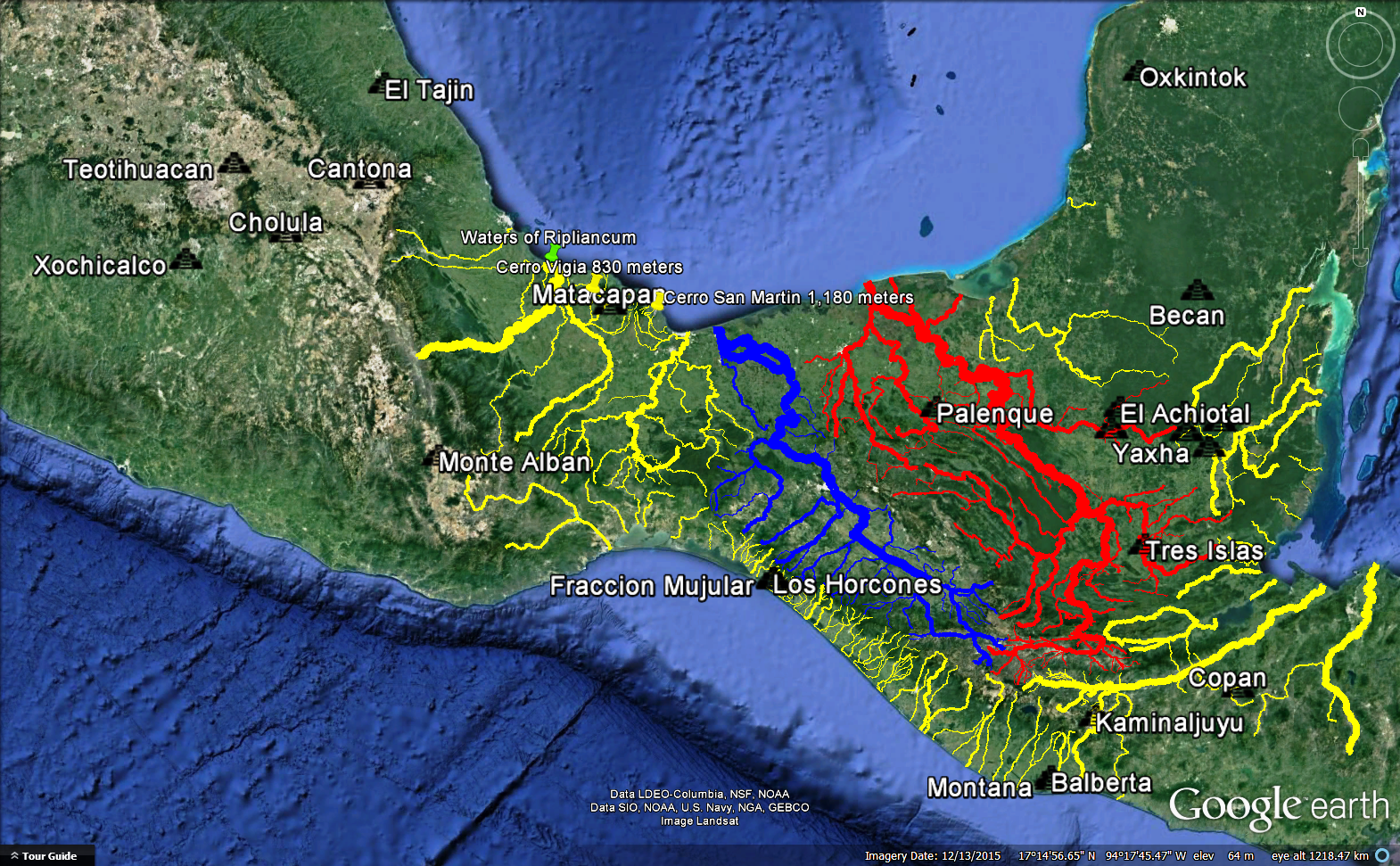
Book of Mormon Lands Map January 2016." We had not analyzed Ramah/Cumorah at that time. We follow John L. Sorenson, Joseph L. Allen, and many others on Nephi as Kaminaljuyu. We follow V. Garth Norman on Zarahemla as Nueva Esperanza - Calatraba. According to this correlation, Zarahemla is at a heading of 339 degrees NNW from Nephi.
Proposed Direction Nephi to Zarahemla
Our proposed Ramah/Cumorah is at a heading of 313 degrees which is nearly due NW from Nephi.
Proposed Direction Nephi to Ramah/Cumorah
Criterion 24 satisfied.

25. Our proposed Zarahemla is 373 air kilometers from our Nephi. See direction image above. Our proposed Ramah/Cumorah is 604 air kilometers from our Nephi. See direction image above. In these correlations the air distance from Nephi to Ramah/Cumorah is 1.619 times the air distance from Nephi to Zarahemla. Criterion 25 satisfied.

26. As the images in #24 indicate, our Zarahemla is in the coastal plain at an elevation of 24 meters. Our Ramah/Cumorah is in the coastal plain at an elevation that rises gradually from sea level to the base of the hill at about 200 meters and then up the steep slopes to the summit.
Proposed Ramah/Cumorah in the Coastal Plain
Criterion 26 satisfied.

27. Our proposed Ramah/Cumorah is 36 air kilometers WNW from the large, north-flowing Coatzacoalcos.
Coatzacoalcos to Cerro San Martin
Criterion 27 satisfied.

28. To go from Nephi to Zarahemla in our proposed correlation, you go through the mountains, past the fall line, into the large coastal plain, and approach the sea. To go from Nephi to Ramah/Cumorah in our proposed correlation, you go through the mountains, past the fall line, into the large coastal plain, and approach the sea.
Relative Locations of Proposed Nephi, Zarahemla, & Ramah/Cumorah
Criterion 28 satisfied.

29. Our Zarahemla and the area around our Ramah/Cumorah are both in the climate zone known as Am Tropical Monsoon in the Koppen Climate Classification. This map is from INEGI, so it does not include Guatemala.
Climatic Zones in Southern Mexico
The Koppen Climate Classification for Guatemala City, on the other hand, is Cwb Oceanic Subtropical Highland. These two climates are very different with the subtropical highland generally considered superior for creature comfort. The people in Guatemala City justifiably brag about their "eternal spring." Criterion 29 satisfied.

30. We overlay a map of known Olmec sites on a topographic base with our river network and modern roads.
Sites with Known Olmec Influence
The area labeled "Olmec Oaxaca" that includes Monte Alban is over 300 kilometers from our hill Shim if you follow the Papaloapan through the Sierra Madre Oriental. Based on our standard distance measure (see the article "Land Southward Travel Times") central Oaxaca is "many days" from the Tuxtlas. To go eastward from the Tehuacan Valley one must "come over" the Sierra Madre. The Olmec sites in Oaxaca are in fact adjacent to our greater land Desolation.
Proposed Land Desolation by Olmec Sites in Oaxaca
We set a terrain plane at 1,550 meters elevation.
Oaxaca Olmec Sites Higher than 1,550 Meters
The Oaxaca Valley is definitely an upland. Criterion 30 with all sub-points satisfied.

For information about another research effort that also concluded Cerro San Martin is a high likelihood candidate for Ramah/Cumorah, see the article "Linguistic Cumorah."

For still another criterion supporting San Martín Pajapan as hill Ramah/Cumorah, see the article "Many Waters." For yet another see the article "Zeroing in on Cumorah."

Article by Kirk Magleby who volunteers as Executive Director of Book of Mormon Central, world's premiere source of reliable Book of Mormon contextual material in English and Spanish.

Article last updated April 23, 2020