- hill
- ruin mound or heap, piled-up corpses
- priesthood, priest, priestess
- desolate, God-destroyed place (if cognate with Gomorrah)
- light arises
A hill is something we may reasonably expect to find on a modern map. The text gives us enough information about Ramah/Cumorah to enable intelligent searching. These hills in Tamaulipas, Oaxaca, and Veracruz have been seriously studied and proposed as candidates:
 |
| Proposed Ramah/Cumorah Locations |
An expedition led by the intrepid and indefatigable Warren Aston spent three weeks in this area in October - November, 2016. The three man team systematically explored each of the proposed Ramah/Cumorah candidates, analyzing it in light of relevant textual criteria. My proposed criteria are itemized 1 - 30 below.
Ramah/Cumorah is a hill, not a mountain. In the text, mountains and hills are of the same genre Helaman 12:9, 3 Nephi 4:1, but mountains are more massive 2 Nephi 4:25, 2 Nephi 12:2, 14. The Book of Mormon only once uses an adjective to modify "hill," and that sense is diminutive 2 Nephi 15:1. Mountains on the other hand are frequently modified with adjectives emphasizing their grandeur Helaman 14:23, 3 Nephi 8:10. The word "mountain" itself is even used as an adjective implying large size Ether 2:24, Ether 6:6. On the small end of the scale, a hill can be man-made 2 Nephi 17:25. So, Ramah/Cumorah has larger and higher mountains 1 in its environment.
Ramah/Cumorah is a singularity, as are the other nine named hills (Amnihu, Comron, Ephraim, Jerusalem, Manti, North of Shilom, Onidah, Riplah, Shim) in the text. "Mount" and "hill" are used similarly, almost interchangeably 2 Nephi 20:32. Four mounts are named (Antipas, Shelem, Sinai, Zion), Shelem being noteworthy for its elevation. Hills and mounts with names are always in the singular. Mountains, on the other hand, are often in the plural 1 Nephi 12:4, Jacob 4:6, Helaman 11:25. One mountain, Zerin, is named Ether 12:30 and it clearly was an isolate rather than a contiguous chain. Other discrete mountains are similarly referenced with singular pronouns Helaman 10:9, Helaman 12:17, 3 Nephi 8:10. This means Ramah/Cumorah is self-contained 2 rather than part of an extended mountain range.
Ramah/Cumorah was in the Nephite land northward 3 Mormon 2:29, Ether 1:1. This places it in a location prone to seismic and volcanic activity 4 3 Nephi 8:12.
Ramah/Cumorah is in a land with high average annual rainfall 5 Mormon 6:4. There are so many well-watered areas in southern Mexico that in order for waters, rivers, and fountains to be useful differentiators, Ramah/Cumorah must be near more arid territory 6.
Ramah/Cumorah was in a land that afforded the Nephites a potential advantage 7 over their enemies Mormon 6:4. That advantage was probably due to crop yields or access to other food resources such as fish or wild game. It may also have come from tactically favorable terrain or access to materials for armament fabrication. The advantage probably did not come from man-made fortifications which are not mentioned again in the text after the city of Desolation was abandoned ca. A.D. 362 Mormon 3:6.
Eastward from Ramah/Cumorah is a seacoast 8 Ether 9:3. From the hill to the sea one does not cross over any significant natural barriers 9 such as a mountain or river. This implies proximity to the sea 10.
Northward from Ramah/Cumorah is a relatively large body of water 11 the Nephites called Ripliancum Ether 15:8-11.
Ramah/Cumorah is large enough that 230,000 people could encamp around it for a period of up to four years Mormon 6:4. Allowing 25 square meters of space per person, that means a refugee camp with an area of 5,750,000 square meters or 575 hectares 12. The Nephites camped around about the hill. As we have noted elsewhere in the text Alma 48:8, Alma 62:34, the phrase "round about" implies circularity. The hill likely has a roughly circular shape 13. The fact that the people were living in tents at year end Mormon 6:5 implies a mild climate 14.
The names "Riplah" and Ripliancum" are probably linguistically related as the Book of Mormon Onomasticon suggests. Moroni himself defines "Ripliancum" as meaning "large, or to exceed all" Ether 15:8. This suggests that Riplah also may mean massive, abundant, or surpassing. See the blog article "Hill Riplah" where we correlate it with Cerro Pampache, the largest detached hill in highland Guatemala. Based on this etymology, it is likely that Ramah/Cumorah is significantly smaller 15 than Riplah.
The doomed Nephites had a clear view of approaching Lamanite armies Mormon 6:7. This means Ramah/Cumorah is surrounded by plains 16. The hill and surrounding plains are compact enough 17 that Lamanite armies could leave camp, travel to the dug-in Nephites, slaughter 230,000 people, and return to their camps within a single 24 hour period Mormon 6:11.
Ramah/Cumorah was high enough 18 and symmetrical enough 19 that from the summit Mormon and Moroni could view nearly a quarter of a million corpses spread across the entire field of battle Mormon 6:11-15.
Ramah/Cumorah was a significant landmark 20 known to both the Nephites and Lamanites Mormon 6:2-3.
Shim is a second hill, probably westward 21 from Ramah/Cumorah Ether 9:3. Some natural barrier 22 such as a mountain or river separated the two so travelers had to come over from one to the other.
The Nephites in their final decades retreated northward Mormon 2:3 and finally abandoned the land southward completely Mormon 2:29. It seems odd, then, that Nephite survivors of the final battle fled from Ramah/Cumorah southward where they were all promptly killed by Lamanites Mormon 6:15, Mormon 8:2. Why did the survivors not flee northward? Why did the entire Nephite nation not simply migrate en masse northward as many before them had done Alma 63:4, Helaman 3:3? Some force northward 23 from Ramah/Cumorah was so powerful and threatening that Nephite refugees preferred to flee southward and take their chances among Lamanites bent on their destruction Mormon 8:7.
Ca. 121 B.C., an exploring party left the city of Nephi, traveled to the Ramah/Cumorah area, found Ether's 24 gold plates, returned to Nephi with artifacts, and reported that they had found the ruins of the destroyed land of Zarahemla Mosiah 8:7-11, Mosiah 21:25-27. King Limhi did not doubt their report, which is one of the reasons he received Ammon so joyously Mosiah 7:14, Mosiah 21:24. Zeniff had made the round trip from Nephi to Zarahemla twice in sizable companies. Zeniff was a record-keeper Mosiah 25:5 as was his grandson, Limhi Mosiah 28:11. As Limhi's 43 explorers left Nephi bound for Zarahemla, they almost certainly had some idea about:
- the general direction of travel from Nephi to Zarahemla
- the approximate distance from Nephi to Zarahemla
- the approximate elevation of Zarahemla relative to Nephi
- Zarahemla's location west of river Sidon
- Zarahemla's location relative to mountains, fall line, coastal plain, and the sea
- it should be in the same general direction from Nephi 24 as Zarahemla.
- its air distance from Nephi should be between .5X and 2X the Nephi - Zarahemla distance 25.
- its elevation should be roughly similar to Zarahemla's 26.
- it should be west of a large, north-flowing river 27.
- it should be in a similar location as Zarahemla relative to mountains, fall line, coastal plain, and the sea 28.
Omer who was the fifth generation from Jared a) departed out of the land of Moron, b) traveled many days, c) came over a natural barrier such as a mountain or river, d) passed by hill Shim, e) came over another natural barrier to hill Ramah/Cumorah, then f) went eastward and settled on the seacoast at Ablom Ether 9:3. Moron was near land Desolation Ether 7:6 and up in elevation Ether 7:5. A viable candidate for the land of Moron must be many days travel from Ramah/Cumorah 30.
--
After considering these 30 proposed criteria, I believe the correlate that best fits the text is 1,180 meter Cerro San Martin (not Volcan San Martin which is an active volcano) in the Tuxtlas of southern Veracruz. Cerro Vigia and Cerro Rabon are both candidates for hill Shim.
 |
| Cerro San Martin in Context |
--
1. We set a semi-opaque terrain plane at 700 meters. All points higher than that show through in natural color.
 |
| Tuxtlas with 700 Meter Terrain Plane |
2. We lower the terrain plane to 300 meters and zoom in on Cerro San Martin.
 |
| Cerro San Martin with 300 Meter Terrain Plane |
3. We along with many other Book of Mormon mapmakers consider the main channel of the Coatzacoalcos a likely candidate for part of the land northward/land southward boundary.
 |
| Proposed Lands Northward/Southward Border Along the Coatzacoalcos |
4. This map of volcanoes active in the Holocene Epoch (last 10,000 years) is from the Smithsonian's Global Volcanism Project.
 |
| Mesoamerican Volcanoes Active in the Holocene |
 |
| Significant Mesoamerican Earthquakes 1900-2016 |
5, 6. These isobars showing average annual rainfall are from INEGI.
 |
| Average Annual Precipitation |
7. Cerro San Martin is surrounded by rich cropland, grassland, and tropical forest. It is 5 km from the seacoast and 30 km from freshwater Lake Catemaco where more than 1,000 licensed commercial fisherman earn their livelihood casting small nets on its waters. Deer are plentiful in the region. Large quantities of snails are harvested commercially for food. This is a bountiful area with a potentially high carrying capacity.
 |
| Ecology of Eastern Tuxtlas |
 |
| Topography of Cerro San Martin, Google Maps Terrain Layer |
8. Five kilometers eastward from Cerro San Martin lies the Gulf of Mexico.
 |
| Eastward to the Sea |
9, 10. Zooming in, we find no natural barriers a traveler would have to cross over to go the short distance from Cerro San Martin to the sea.
 |
| Unobstructed Travel from the Hill to the Sea |
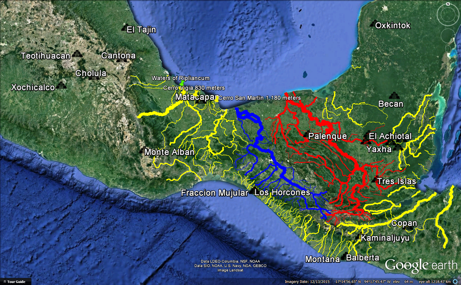
11. The Papaloapan is the second largest river in Mexico by discharge volume. Many Book of Mormon geographers, ourselves included, consider the extensive wetlands near its mouth to be the Waters of Ripliancum. They are the second largest wetlands in Mexico, and the largest in the territory we correlate with the Nephite land northward. This map shows our river network superimposed on an INEGI map of permanent bodies of water.
 |
| Proposed Waters of Ripliancum WNW from Cerro San Martin |
12. We superimpose a rough quadrangle with an area of 575 hectares on top of Cerro San Martin. Of course, the actual surface area of the hill is much greater due to folding, but this crude graphic shows that a hill the size of Cerro San Martin is in the ballpark of reasonableness for hosting a refugee camp with nearly a quarter of a million displaced persons.
 |
| 575 Hectares Relative to Cerro San Martin |
13. Cerro San Martin is roughly circular in shape as this terrain plane set to 500 meters clearly shows.
 |
| Classic Conical Volcano |
14. Coatzacoalcos is a major city about 30 kilometers from Cerro San Martin. These are the average annual high and low temperatures for Coatzacoalcos as reported by World Weather Online.
 |
| Average High and Low Temperatures near Cerro San Martin |
15. Cerro San Martin is 1,180 meters high and has an area of approximately 15 square kilometers.
 |
| Rough Outline of Cerro San Martin |
 |
| Rough Outline of Cerro Pampache |
16. Cerro San Martin is surrounded by level ground sloping outward as this topographical map shows.
 |
| Cerro San Martin and Environs |
17. If the invading Lamanite armies camped about where the towns of Pajapan and Tatahuicapan are today, they would have been 3 - 5 kilometers from the base of the hill.
 |
| Distance from Pajapan to Cerro San Martin |
18, 19. From the 1,180 meter summit of Cerro San Martin, Mormon and Moroni would have had a clear view of the battlefield below. Concentric circles show the distance from the summit in 1 kilometer increments.
 |
| Field of Vision at 1, 2, 3, and 4 km from Summit |
 |
| Field of Vision in 1 Kilometer Increments |
20. Cerro San Martin is the easternmost point in the Tuxtlas. It is the peak nearest the lower Coatzacoalcos. It is the Tuxtla summit closest to the ocean. It has over 900 meters of vertical rise from any point on its periphery. It stands apart.
 |
| Cerro San Martin in Topographical Context |
 |
| Cerro San Martin in Larger Shaded Relief Context |
21, 22. Our current proposal for hill Shim is Cerro Vigia, westernmost peak in the Tuxtlas. As this map shows, Cerro Vigia is westward from Cerro San Martin.
 |
| Proposed Hill Shim Westward from Proposed Ramah/Cumorah |
23. If our correlation of Cerro San Martin with Ramah/Cumorah is correct, then the powerful threatening force northward was Teotihuacan.
 |
| Sites with Significant Teotihuacan Influence |
 |
| Matacapan - Teotihuacan Outpost |
24. Our large-scale correlation, as it stood in January, 2016, is laid out in the blog article "Book of Mormon Lands Map January 2016." We had not analyzed Ramah/Cumorah at that time. We follow John L. Sorenson, Joseph L. Allen, and many others on Nephi as Kaminaljuyu. We follow V. Garth Norman on Zarahemla as Nueva Esperanza - Calatraba. According to this correlation, Zarahemla is at a heading of 339 degrees NNW from Nephi.
 |
| Proposed Direction Nephi to Zarahemla |
 |
| Proposed Direction Nephi to Ramah/Cumorah |
25. Our proposed Zarahemla is 373 air kilometers from our Nephi. See direction image above. Our proposed Ramah/Cumorah is 604 air kilometers from our Nephi. See direction image above. In these correlations the air distance from Nephi to Ramah/Cumorah is 1.619 times the air distance from Nephi to Zarahemla. Criterion 25 satisfied.
26. As the images in #24 indicate, our Zarahemla is in the coastal plain at an elevation of 24 meters. Our Ramah/Cumorah is in the coastal plain at an elevation that rises gradually from sea level to the base of the hill at about 200 meters and then up the steep slopes to the summit.
 |
| Proposed Ramah/Cumorah in the Coastal Plain |
27. Our proposed Ramah/Cumorah is 36 air kilometers WNW from the large, north-flowing Coatzacoalcos.
 |
| Coatzacoalcos to Cerro San Martin |
28. To go from Nephi to Zarahemla in our proposed correlation, you go through the mountains, past the fall line, into the large coastal plain, and approach the sea. To go from Nephi to Ramah/Cumorah in our proposed correlation, you go through the mountains, past the fall line, into the large coastal plain, and approach the sea.
 |
| Relative Locations of Proposed Nephi, Zarahemla, & Ramah/Cumorah |
29. Our Zarahemla and the area around our Ramah/Cumorah are both in the climate zone known as Am Tropical Monsoon in the Koppen Climate Classification. This map is from INEGI, so it does not include Guatemala.
 |
| Climatic Zones in Southern Mexico |
30. We overlay a map of known Olmec sites on a topographic base with our river network and modern roads.
 |
| Sites with Known Olmec Influence |
 |
| Proposed Land Desolation by Olmec Sites in Oaxaca |
 |
| Oaxaca Olmec Sites Higher than 1,550 Meters |
For information about another research effort that also concluded Cerro San Martin is a high likelihood candidate for Ramah/Cumorah, see the article "Linguistic Cumorah."
For still another criterion supporting San Martín Pajapan as hill Ramah/Cumorah, see the article "Many Waters." For yet another see the article "Zeroing in on Cumorah."
Article by Kirk Magleby who volunteers as Executive Director of Book of Mormon Central, world's premiere source of reliable Book of Mormon contextual material in English and Spanish.
Article last updated April 23, 2020


