 |
| Smoking Gun: Scientific Evidence Highly Favoring a Particular Theory Shutterstock Licensed Image |
 |
| Significant Book on the Maya and the Sea |
No place in the ancient Maya world was more than 260 kilometers (160 miles) from the open ocean.
 |
| Circle with 258 Kilometer Radius |
The sea loomed large in the daily life and thought of the Nephites. This list ranks various ecological features by the number of verses in the text that mention them. Features where at least some of the passages refer to the sea are highlighted in yellow.
- 212 wilderness
- 123 water & waters
- 81 sea
- 68 borders
- 43 mountain
- 41 river
- 36 valley
- 34 hill
- 30 depths
- 24 seashore
- 19 mount
- 13 forest
- 11 isle & isles
- 9 waves
- 8 deep (as a noun)
- 8 plain (as a noun)
- 3 islands
- 3 thicket
- 2 shore
- 2 whale
- 2 grass
- 1 beach
- 1 grove
--
The Maya believed some of their ancestors originally came from across the sea (p. 15). The Book of Mormon chronicles 3 migrations that originally came from across the sea 1 Nephi 18:23, Omni 1:15,
Ether 6:12.
In their Popol Vuh, the K'iche' Maya say that their ancestors came from "across the sea." K'iche' scholar Allen Christenson believes the sea they refer to may be the Bay of Chetumal which matches the geography of their legendary migration route.
--
The Maya believed they were surrounded by the sea (p. 15). Mormon wrote that the land southward was nearly surrounded by water Alma 22:32. If you trace the coastline and land bridges of the land mass east of the Coatzacoalcos and west of the Ulua (rougthly the area inside the circle on the map below) 88% of the littoral is salt water ocean and 12% is dry land.
 |
| Maya Area Nearly Surrounded by Water |
--
The Maya conceived of the earth as a turtle or crocodile floating on the sea (pp. 210-112).
 |
| Kaminaljuyu Sculpture 2, the Earth Crocodile Drawings by Lucia Henderson |
This smoking gun evidence says Book of Mormon lands are in a watery environment - such as Mesoamerica - with coastal characteristics.
--
The Maya identified four seas, one in each of the four cardinal directions (pp. 15, 204, 212-213).
The Nephites identified four seas, one in each of the four cardinal directions Helaman 3:8.
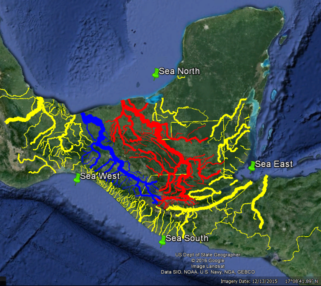 |
| Seas North, South, East & West According to the January, 2016 Book of Mormon Lands Map |
--
Now things get really interesting. The Maya and other ancient Mesoamericans were unequivocal in their identification of the east sea - it was the Caribbean along the coasts of Guatemala, Belize, and Quintana Roo - the sea from which the sun rises. This is the sea called the fiery pool because of its solar association.This is the sea whose color was red, the eastern color. This is the sea that symbolized fertility and abundance because the Maya believed rain came from the east (pp. 204, 212, 214-215).
This smoking gun evidence favors maps by Ric Hauck, Joe and Blake Allen, Shelby Saberon, Elder Clate Mask, Jr., and Kirk Magleby (this blog), all of whom correlate the east sea with the Caribbean. It casts serious doubt on maps by Garth Norman and Aric Turner, both of whom wrap the east sea up around the Yucatan Peninsula and down into the Gulf of Mexico. It all but eliminates John Sorenson's model which correlates the east sea with the western portion of the Gulf of Mexico.
See the article "Maya Place Names" for 3 other Book of Mormon toponyms ("the east by the seashore" of Alma 22:29; "the river" of Alma 43:52, and "bountiful" of Alma 53:3) that now have an ancient Maya counterpart.
--
The Maya viewed the world as divided into four quarters oriented to the cardinal and intercardinal points (pp. 204, 212-213).
Here are three Maya depictions of this quadripartite concept from Fiery Pool p. 213.
From left to right, these images are from the Book of the Chilam Balam of Chumayel, Mayapan, and Kaminaljuyu. All drawings by Karl A. Taube.
This smoking gun evidence favors maps by Ric Hauck, Joe and Blake Allen, Shelby Saberon, Elder Clate Mask, Jr., and Kirk Magleby (this blog), all of whom correlate the east sea with the Caribbean. It casts serious doubt on maps by Garth Norman and Aric Turner, both of whom wrap the east sea up around the Yucatan Peninsula and down into the Gulf of Mexico. It all but eliminates John Sorenson's model which correlates the east sea with the western portion of the Gulf of Mexico.
See the article "Maya Place Names" for 3 other Book of Mormon toponyms ("the east by the seashore" of Alma 22:29; "the river" of Alma 43:52, and "bountiful" of Alma 53:3) that now have an ancient Maya counterpart.
--
The Maya viewed the world as divided into four quarters oriented to the cardinal and intercardinal points (pp. 204, 212-213).
 |
| Cardinal and Intercardinal Points |
 |
| Earth Turtles Divided into Four Quarters |
The Book of Mormon mentions quarters of the land fourteen times e.g. Alma 52:10.
This smoking gun evidence favors maps by Ric Hauck, Joe and Blake Allen, Aric Turner, Garth Norman, Shelby Saberon, Elder Clate Mask, Jr., and Kirk Magleby (this blog), all of whom correlate the directions north, south, east and west in the Book of Mormon with the solar-derived cardinal directions. It repudiates John Sorenson's much-maligned attempt to skew the cardinal directions. In the words of Mark Wright, an accomplished Mesoamericanist on the BYU Religion Faculty, "Rio Azul Tomb 12 is determinant." His mentor, Karl Taube, in Fiery Pool agrees (p. 204). Rio Azul Tomb 12 on its four walls displays the Maya glyphs for the four directions all in their correct orientation. Corroborating information is found on Copan Stela A and the Yotz Kanpet ceramic bowl rim text.
--
Article by Kirk Magleby who volunteers as Executive Director of Book of Mormon Central, world's premiere source of reliable Book of Mormon contextual material in English and Spanish.
Article updated January 22, 2018
--
Article by Kirk Magleby who volunteers as Executive Director of Book of Mormon Central, world's premiere source of reliable Book of Mormon contextual material in English and Spanish.
Article updated January 22, 2018