The Book of Mormon text describes a city of Manti
Alma 56:14 within a land of Manti
Alma 17:1. It also mentions a Nephite spy with that name
Alma 2:22, as well as the hill near Zarahemla
Alma 1:15 where Nehor was executed for killing Gideon.
Hill Manti has its own article in this blog.
--
What we know about the land of Manti from the text (the numbers
1-
25 with
aqua background indicate criteria we will use to identify Manti on the modern map):
- Manti is first mentioned in the 11th year of the reign of the judges (ca. 81 BC) Alma 16:6. The Nephites were aggressively expanding their settlements during this era Mosiah 27:6, Alma 22:29, Alma 50:18.
- Manti was the southernmost land along the river Sidon corridor under Nephite political control. 1
- South of Manti lay the south wilderness Alma 16:6. 2
- The river Sidon flowed through the south wilderness Alma 16:6. 3
- The portion of the river Sidon flowing through the south wilderness was upstream from Manti Alma 16:6, and part of the south wilderness lay east of the river. This means the river Sidon flowed generally from south to north in this part of its course. 4
- A favored route from Zarahemla to Manti was to cross over the river Sidon and travel south along the east side of the river. We see this with Captain Zoram and his armies Alma 16:7. We see it again in Alma II's travels Alma 17:1. It was also the route the sons of Mosiah II used when they returned north to Zarahemla after their fourteen year mission to the Lamanites in the greater land of Nephi Alma 17:4. 5
Alma 22:27-34 is a special textual case. This is Mormon's principal geographic explication, crafted in part to help those of us in the latter-days identify the Nephite homeland. We will deal with this passage in its entirety in a separate article. For the time being, this is what we learn about Manti from Mormon's cardinal geography text:
- From the Lamanite emperor's perspective in the land of Nephi, a narrow strip of wilderness running east-west from sea to sea lay south of the land of Manti. 6
- South of the narrow strip of wilderness lay a north wilderness. 7
- The head of the river Sidon was in this north wilderness. 8
The wilderness that was south from the Nephites' land of Zarahemla perspective
Alma 16:6 is the same wilderness that was north from the Lamanites' land of Nephi perspective
Alma 22:27. Other things about Manti we can glean from the text:
- In the 18th year of the reign of the Judges (ca. 74 BC) Manti was one of the younger and weaker parts of the Nephite polity Alma 43:24.
- The invading Lamanite army under Zerahemnah left the land of Antionum/land of Jershon border which was in the eastern part of the greater land of Zarahemla near the east sea Alma 27:22 and traveled in an arc through the south wilderness near the head of Sidon Alma 43:22. This means the land of Manti was inland rather than near the east sea coast. 9
- After travelling some distance westward over the wilderness, Zarahemnah intended to come into the land of Manti from the south Alma 43:24.
- From the land of Jershon, Captain Moroni went over into the land of Manti, arriving at the battle site south and upstream from Manti before Zarahemnah Alma 43:25.
- Going a more direct route from Jershon to Manti, Captain Moroni arrived far enough ahead of Zarahemnah that he had time to recruit additional men into his army before the battle Alma 43:26.
- Manti was the principal land in the southern quadrant (quarter) of the greater land of Zarahemla Alma 43:26.
The battle between Zarahemnah on the Lamanite side and Lehi + Moroni on the Nephite side sheds light on some river topography just south of the land of Manti:
- The hill Riplah lay east of the river Sidon Alma 43:31, Alma 43:52, Alma 49:16. 10
- The hill Riplah ran roughly east-west because it had both north and south sides Alma 43:34, Alma 43:31, Alma 43:35. 11
- The hill Riplah was large enough to conceal part of an army on its south flank Alma 43:35. 12
- Coming from the east, the Lamanite army had to go up in elevation to skirt around the north side of hill Riplah Alma 43:34. 13
- Passing by hill Riplah, the Lamanites then descended into a valley that opened to the river Alma 43:35. 14
- On the west side of the river lay another valley Alma 43:27. 15
- The valley on the west side of the river was near the river, but did not necessarily open to the river Alma 43:27. 16
- The Lamanites had originally intended to cross the river Sidon and attack the land of Manti from west of the river Alma 43:35.
- From the valley on the western side of the river, it was possible to travel downstream toward the land of Manti Alma 43:42. 17
- Additional hiding places for more military forces lay between the valley on the western side of the river and the land of Manti Alma 43:32, Alma 43:42. 18
- These additional downstream hiding places were not very far from the valley on the western side of the river because the Lamanite survivors ended up in one massed group on the west bank of Sidon across the river from Lehi's army Alma 43:51. 19
In addition, the text tells us that:
- The cities of Antiparah on the west near the seacoast Alma 56:31, Cumeni, Zeezrom and Manti on the east (relative to Judea where Helaman began his military campaign) near the river Sidon were points Alma 56:14 along the Nephites' south western front in their war with the Lamanites under Ammoron.
- From the south western front, the Lamanites could have gone down northward to Zarahemla or across the head of Sidon over eastward to Nephihah Alma 56:25.
- The route from Manti eastward to Nephihah was well established, like the route from Manti northward to Zarahemla Alma 56:25, 59:6.
- Lamanite emperor Ammaron's original war plan called for an invasion up the west coast of the greater land of Zarahemla:
- There had been a significant Lamanite presence in this area for some time Alma 22:28.
- Ammaron's first major military action after he ascended to the throne was in this area Alma 52:12.
- Ammaron maintained a large troop strength in the southern sector of this west coast area Alma 56:34, 36.
- Until Helaman arrived with fresh troops to reinforce the army of Antipus, the Lamanites' battle orders had been to go on the offensive and pursue their invasion up the west coast Alma 56:18.
- The Nephites further north up the west coast were expecting a Lamanite invasion Alma 56:22.
- After one day's travel northward from Antiparah, Helaman's warriors entered wilderness Alma 56:39, 40.
- The local land of Zarahemla contained the designated prisoner of war camp Alma 56:57 for Lamanite captives taken by Helaman's army fighting on the south western front.
- On the south western front, Antiparah, furthest from the city of Nephi, was the first Lamanite possession to revert back into Nephite hands Alma 57:4.
- After re-capturing Antiparah, Helaman then turned his attention to Cumeni Alma 57:7, the next city on the line eastward toward Manti.
- From Cumeni, the local land of Zarahemla was down in elevation Alma 57:15, 16.
- Manti was the most strategic Lamanite possession on the south western front. From Manti, the Lamanites dispatched men and materiel to the other cities in the area under their control Alma 57:17, 22.
- After re-capturing Antiparah on the west and Cumeni in the middle of the south western front, Helaman turned his attention eastward to the city of Manti near the river Sidon Alma 58:1.
- The city of Manti adjoined wilderness on one side, and that wilderness was very close to the city Alma 58:13, 14. 20
- Helaman led his army laterally (east or west) away from the city of Manti through the wilderness for part of a day, then left the wilderness and turned northward toward the land of Zarahemla Alma 58:23, 24. 21
- When the Lamanite army realized they were headed down toward Zarahemla, they panicked, backtracked into the wilderness, and camped for the night Alma 58:24, 25. 22
- Near the Lamanite campground, Helaman knew an alternate route back to the city of Manti Alma 58:26. 23
- In the general vicinity of the Lamanite campground, the land of Manti did not extend far beyond the river Sidon and the city of Manti because Helaman's army went beyond the boundary of the land in only one day's march Alma 58:26.
- Helaman's new route back to Manti was not necessarily shorter than his original path through the wilderness because even after marching all night, his army still had some distance to go to reach the city Alma 58:27. 24
- After Helaman's Nephite army liberated the city of Manti, part of the displaced Lamanites fled southward back home to the land of Nephi Alma 58:38.
- Other Lamanites from the land of Manti and beyond fled eastward and participated in an attack on the city of Nephihah Alma 59:6, 7.
Some interesting questions suggest themselves as we ponder the nuances of Manti and the south western war front:
- Q. Why did Helaman send the intercepted Lamanite provisions from the siege of Cumeni to Judea Alma 57:11? A. Judea and Antiparah were near each other not far from the west sea Alma 56:31. These cities were on the southern edge of Nephite territory, positioned to defend Nephite possessions further north from Lamanite incursions Alma 56:22. Judea had significant defensive fortifications Alma 56:20. Helaman left part of his army to defend Judea & Antiparah when he went on the offensive to re-take Cumeni Alma 57:8. While still in Judea, Helaman had recently received ample provisions from the Nephite government Alma 57:6. So, when a convoy of Lamanite provisions fell into Nephite hands, Helaman sent the windfall back to his defensive garrison headquartered in Judea because the Judea - Antiparah area, in the south western corner of Nephite lands, was further away from the city of Zarahemla than was Cumeni. The local land of Zarahemla and the lands surrounding it were the breadbasket as well as the population center of the Nephite nation Alma 57:6. Zarahemla - Judea was a longer supply line than Zarahemla - Cumeni, so Helaman was being prudent and reducing risk by forwarding surplus supplies to his remotest outpost. He knew how tenuous supply lines can be in wartime Alma 58:7. He was also thinking strategically. Even if the Nephites lost the anticipated battle for Cumeni, moving the provisions to Judea and the prisoners of war to Zarahemla would prevent them from being re-captured by the Lamanites Alma 57:11. Forestalling Lamanite reinforcement of men and materiel was always a strategic priority Alma 56:57.
- Q. Why were Captains Moroni and Helaman so unaware of each other's circumstances? A. In the 26th year of the reign of the judges, Helaman marched with his 2,000 stripling warriors to join Antipus in the city of Judea Alma 56:9. 3+ years later, in the last few days of the 29th year, Helaman was comfortably bivouacked in Manti and he had time to write a lengthy epistle to his friend and fellow commander, Captain Moroni Alma 58:38, 39. Summarizing the results of his campaigns in and around Judea, Cumeni and Manti, Helaman recounted many significant details that were new to Captain Moroni, his superior in the Nephite military Alma 59:1 - 3. In his epistle, Helaman demonstrates a surprising lack of knowledge about the conduct of the war in Moroni's sector Alma 58:35. Fresh recruits recently arrived from the Nephite capital, Zarahemla, were similarly ignorant of fundamental conditions in their own government Alma 58:34. Captain Moroni, the top military officer in the Nephite nation Alma 43:16, did not even know that his own government had been forced to re-locate after dissenting factions occupied the capital city Alma 61:5. The fog of war is very real. Some war-related information is confidential. Other explanations for the stunning knowledge vacuum in which Captains Moroni and Helaman operated in their respective quarters of the land Alma 56:1, 58:35 include:
- the Nephite government under Parhoran (critical text orthography) was operating in exile in the land of Gideon Alma 61:5.
- Lamanite raiding parties were wandering around the countryside disrupting the normal flow of commerce and communication Alma 58:6.
- Normal methods of war-time communication included written epistles Alma 54:4, 61:21 which were not necessarily easy to compose, and small delegations of people Alma 52:20, 58:4 which posed their own logistical challenges.
From this exegesis on the war-time movement of men, goods and information, we can deduce that Manti was quite remote and isolated from the local land of Zarahemla and from the Nephite cities near the east coast. The west coast cities of Judea & Antiparah were even more remote. We would expect distances in the hundreds, not dozens of air kilometers
25 consistent with Helaman's lament that the Nephite armies were spread far too thin to adequately defend their vast extension of territory
Alma 58:32.
--
From the foregoing, we have 25 (
1 -
25)very precise criteria that will help us identify Manti on the modern map. Having previously established that the Usumacinta must be the river Sidon (see the article "
The River Sidon - Precis" in this blog), our candidate for the city of Manti is the pre-classic and classic archaeological site of Chama in Alta Verapaz, Guatemala. As with all graphics in this blog, click to enlarge.
 |
Relative location of the site of Chama in Alta Verapaz,
proposed Book of Mormon city of Manti |
Using Google Earth, let's see how well our candidate stacks up against the demanding criteria specified in The Book of Mormon text.
--
1. In the following map, the northern green line demarcates the likely narrow strip of wilderness separating the greater land of Nephi on the south from the greater land of Zarahemla on the north. We'll explore this important topographical feature in a future post. Much of the rugged area in between the two green lines qualifies as wilderness. The proposed land and city of Manti are on the extreme southern edge of Nephite territory north of the narrow strip of wilderness. The site of Chama is 305 meters in elevation at the confluence of the small Sachichaj with the large Chixoy, principal tributary of the Salinas and then the Usumacinta. Criterion 1 satisfied.
 |
Proposed land and city of Manti, southern-most
Nephite polity along the river Sidon corridor |
2,
3. We have two ways of empirically testing candidates for wilderness:
- modern human activity measured by the amount of light emitted into space at night
- known archaeological sites documented by the authoritative EEAMS database
If there is little human activity today and few sites known from antiquity, a given geographic territory is a prime candidate for what The Book of Mormon calls wilderness. Do we find wilderness south of our Manti? We will zoom in on our area of interest and overlay the base map with
NASA's Earth Lights at Night dataset. The modern Guatemalan communities of Coban, Cubulco, Rabinal & Salama, marked with pushpins, show up as bright spots. Note the dark band of low population density both east and west of our proposed head of Sidon (the confluence of the small Salama with the large Chixoy/Negro that forms the Chixoy). We'll investigate the head of Sidon more fully in a subsequent article.
 |
NASA satellite imagery of earth lights at night in the
area south of the proposed city of Manti |
Identifying some of this area of low population density in Google Earth, we create a 1,936 square kilometer polygon that is likely part of The Book of Mormon's south wilderness.
 |
Wilderness south of the greater land of Zarahemla
shaded in greeen |
Overlaying our proposed south wilderness with known archaeological sites, it is clear that this area was sparsely inhabited in antiquity. We have added more of the Usumacinta river system in red and the Polochic river system (which drains to the Caribbean) in yellow because many ancient settlements were located near rivers.
 |
| South wilderness area overlaid with known archaeological sites |
A large wilderness area does lie south of our proposed Manti, and the river Sidon runs through it. Criteria 2 & 3 satisfied.
4. From the head of Sidon in the wilderness to Manti, the river Sidon flows generally northward as the following map illustrates:
 |
River Sidon flowing generally northward through the
south wilderness and the land of Manti |
The south wilderness is upstream from Manti. The south wilderness does extend eastward. The river Sidon does flow generally from south to north in this part of its course. Criterion 4 satisfied.
5. Travelling between our proposed Zarahemla and Manti, it makes sense topographically to stay on the east side of the river because the elevations are lower, there are fewer hills, and the slopes are gentler. In addition, our candidate for the city of Manti, Chama, is east of the river. As an example, the route outlined below in purple goes from Nueva Esperanza II (elevation 38 meters) to Chama (elevation 305 meters) and at its highest point never climbs above 500 meters. Travelling on the west side of the river, on the other hand, it is hard to avoid elevations rising to 800 or 900 meters.
 |
Example route Zarahemla to Manti crossing over the river
Sidon and travelling along the east side of the river |
Staying east of the river also makes sense if one were to continue on from Manti to Nephi via the key waypoints Coban and Salama.
 |
| Easiest route between Manti (Chama) and Nephi (Kaminaljuyu) |
From our proposed Manti to Zarahemla, a logical travel route with obvious logistical advantages does exist east of the river Sidon. Criterion 5 satisfied.
6. 23 air kilometers south of our proposed city of Manti lies a geologic feature so dramatic it is easily visible from space. The subduction zone at the boundary between the North American and the Caribbean tectonic plates has created a line of high cliffs that run in nearly a straight line east to west across Guatemala and Chiapas. This row of cliffs is our candidate for the narrow strip of wilderness that separated Nephite territory on the north from Lamanite territory on the south during the time of Helaman I & Captain Moroni. We have superimposed a high resolution topographic map over Google Earth's base satellite imagery to highlight this prominent geologic rift.
 |
Proposed narrow strip of wilderness between the greater
lands of Nephi on the south and Zarahemla on the north |
We will explore this narrow strip of wilderness in some detail in a subsequent blog entry. For our present purpose, it is enough to note that a viable candidate for the narrow strip of wilderness running from the sea east to the sea west does lie south of our Manti. Criterion 6 satisfied.
7,
8. We zoom in on the area between our proposed Nephi (Kaminaljuyu) and Manti (Chama) with the Usumacinta River system shown in red, the Polochic and Motagua systems shown in yellow, and the narrow strip of wilderness line in green. We then overlay these map features on NASA's Earth Lights at Night spatial dataset and identify some of the modern Guatemalan communities in our field of view. The massive concentration of modern human activity in and around Guatemala City is obvious. It is also clear that a great deal of wilderness lies between the narrow strip of wilderness (green) on the north and the Motagua River (yellow) on the south.
 |
Earth lights at night in the area between
Nephi (Kaminaljuyu) & Manti (Chama) |
We plot this area of low contemporary population density as a 1,936 square kilometer polygon in Google Earth. This highlighted area should be part of The Book of Mormon's north wilderness (from the perspective of the Lamanite emperor in the land of Nephi). Overlaying our map with
EEAMS archaeological site data shows our north wilderness with scant human occupation in antiquity, so it qualifies as a viable Book of Mormon wilderness.
 |
| North wilderness area overlaid with known archaeological sites |
The wilderness south of Manti (from the Nephite's perspective in the greater land of Zarahemla - see criteria 2 & 3 above) and the wilderness north of Nephi (from the Lamanite's perspective in the greater land of Nephi) are one and the same wilderness with multiple points of tangency. The important geographic referent The Book of Mormon calls head of Sidon is in this contiguous wilderness.
 |
| Wilderness south of Manti and north of Nephi |
An attested wilderness does lie south of our proposed narrow strip of wilderness which itself is south of Manti, and our proposed head of Sidon is located in this wilderness area. Criteria 7 & 8 satisfied.
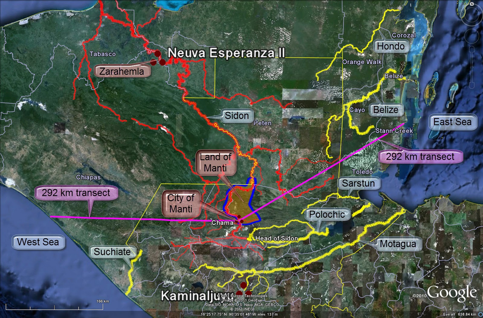
9. We now consider the location of our proposed Manti relative to the east and west sea coasts. The Usumacinta (Sidon) system is in red. The river systems of the Hondo (Azul), Belize, Sarstun, Polochic, and Motagua, all draining to the Caribbean, are shown in yellow. Also in yellow is the Suchiate, draining southward to the Pacific. Chama, our Manti, is shown with purple transects running to the east and west seas respectively. We specifically chose the east sea termination point to be 292 kilometers from Chama, the same length as the western transect.
 |
Proposed Manti with equi-distant
sea east & sea west transects. |
Our proposed Manti is considerably inland from both the east and west seas as The Book of Mormon text indicates. Criterion 9 satisfied.
10,
11,
12. Not far south from Manti, east of the river Sidon we should find a large east-west oriented hill. Zooming in on this area and turning on the terrain layer in Google Maps to better visualize the topography, a prime candidate for the hill Riplah practically jumps off the page.
 |
| Large hill running east-west just south of proposed Manti |
Zooming in still further shows a hill about 20 kilometers long oriented 11 degrees from true east-west.
 |
| Hill 20 kilometers long east of Sidon |
Looking at the slope, we find a knife-edge ridge with very tight contour lines rising more than 1,500 meters from the river below.
 |
| HIll with very steep south slopes |
Some questions and answers about the proposed hill Riplah:
- Q. How far is it from the city of Manti? A. The ridge line is about 20 air kilometers south of the city.
- Q. What is the maximum elevation? A. 2,218 meters or 7,276 feet.
- Q. How steep are the slopes? A. Many of the slopes on the south and west exceed 70% - almost sheer vertical cliffs. The slopes are gentler on the north and the east.
There is a prominent hill south of our Manti that fits the criteria for the hill Riplah. It is east of the river Sidon. It runs east-west. And at 20 kilometers in length, it is large enough to conceal part of an army on its south slopes. Criteria 10, 11 & 12 satisfied.
13,
14. We can trace the likely route Zarahemnah and his Lamanite army traveled as they came in an arc south of the land of Jershon - land of Antionum border, south of the narrow strip of wilderness (the green line), through the east wilderness, near the head of Sidon, to invade Manti from the south. They likely traveled up the Dulce River from the coastal plain, across Lake Izabal, up the Polochic River, and then down the Cahabon River until they came to the eastern slopes of hill Riplah. From there they went up in elevation to pass north of hill Riplah and then descended into the westward sloping valley opening to the river Sidon. This general route is traced in purple in the map below.
 |
| Proposed route of Lamanite army under Zerahemnah |
Focusing on the Cahabon River (in yellow) to river Sidon (in red) portion of the route clarifies the topography around the north side of hill Riplah. Note the elevation profile of the Lamanite route (in purple) along the bottom of the map.
 |
| Proposed Lamanite army route along north side of hill Riplah |
The river at the battle site indicated on the map above is about 310 meters in elevation. So, if our route is correct, the Lamanites under Zarahemnah climbed from about 1,400 meters in elevation just north of present-day San Cristobal Verapaz to 1,900+ meters in elevation to skirt around the north side of hill Riplah. They then dropped quickly down the river valley and began crossing the big river at 310 meters elevation. While they were busy crossing the Sidon, Lehi's troops came down the same river valley behind them and attacked their rearward, killing many and driving the remainder across the river. The topographic details in this area of Alta Verapza, Guatemala fit The Book of Mormon text beautifully. Coming from the east, you do rise in elevation to cross over north of the large hill, and once past the hill you do descend into a river valley that opens to the river Sidon. It would take awhile to ferry a whole army across the large river, leaving those still on the east vulnerable to attack. Criteria 13 & 14 satisfied.
15,
16. Across the river Sidon from the east valley things get very interesting. The west valley is not described as opening to the Sidon, but rather as being near the banks of Sidon. Zooming in on the battle area, we find a west valley that fits Mormon's description precisely. First, though, let's take a look at the likely route the Lamanites would have followed to invade Manti had Captains Moroni & Lehi not defeated them in battle.
 |
| Lamanites' likely planned route to invade Manti |
Before Lehi attacked from the valley east of Sidon, the Lamanites were crossing the river which indicates they planned to invade Manti from the west. Downstream from their crossing point, cliffs impede travel along the river itself, so they would have found their way through the broken country to the west. Zooming in on the area immediately across the river from the east valley, we find another valley hidden behind a low hill, a perfect spot to conceal part of an army.
 |
| Detailed topography around Zarahemnah's river crossing |
Setting a terrain plane at 460 meters elevation shows the round valley west of Sidon and the hill between it and the river very clearly. Everything below 460 meters is white, which includes the main river course. Elevations higher than 460 meters appear as normal satellite imagery. The blue line is a contour representing 500 meters elevation.
 |
| Hidden valley west of river Sidon |
Another view uses shaded polygons to show the battlefield immediately west of Sidon, the hill in between the river and the valley, and the concealed valley west of Sidon. It also shows the proposed route the Lamanites had planned to take into Manti. Note the modern hydroelectric plant on the small river flowing into the Sidon from the east.
 |
| Battlefield topography - Moroni's defeat of Zarahemnah |
The floor of our valley west of Sidon has an area of 356,400 square meters which is 3,836,000 square feet or 88 acres, enough to conceal thousands of soldiers. Our valley east of Sidon is a traditional river valley. Immediately across the river is a non-traditional circular valley blocked from view by a low hill. This topography precisely fits the details described in Alma chapter 43. Lehi's troops could not be concealed in the valley east of Sidon. They hid behind the ridge of hill Riplah near the head of the valley. But immediately across the river on the west, a hidden valley does exist where troops could be hidden from view. Criteria 15 & 16 satisfied.
17. Zooming out to include the city of Manti (Chama) in our field of view, we see more precise details that dovetail with The Book of Mormon text. There is a logical path the Lamanites could have followed to go from the valley west of Sidon to the city of Manti. This path would have avoided the cliffs next to the river and kept Zarahemnah's army out of sight from the residents of Manti until the invading troops were only 2 kilometers from their target.
 |
| Lamanite army's proposed route from their river crossing into Manti |
A militarily viable route to Manti does exist west of the Sidon. Criterion 17 satisfied.
18. Captain Moroni concealed troops in multiple places west of Sidon between Zarahemnah's river crossing point and the city of Manti. Some options for these concealment locations seem obvious when we zoom in on the local topography.
 |
Valleys west of Sidon where Captain Moroni
could have concealed parts of his army |
Multiple logical troop concealment locations do exist in valleys west of river Sidon downstream from the Lamanites' river crossing and upstream from the city of Manti. Criterion 18 satisfied.
19. Placing a ruler on our troop concealment locations in valleys west of Sidon shows that 4 locations are within 3.80 kilometers of each other, and 3 locations are within 2 kilometers of each other.
 |
| Potential troop hiding places in close proximity |
Enough concealment locations exist west of Sidon in close enough proximity that multiple groups of Moroni's sequestered soldiers could have joined the battle with Zarahemnah's Lamanites as the text of Alma 43 indicates. Furthermore, a battlefield plain does exist immediately across the river from the east valley where Lehi's troops were watching the action. All the Lamanite survivors were eventually huddled together in this flat by the river.
 |
Local topography around the battlefield where
Zarahemnah surrendered to Moroni |
The flat on the west of Sidon highlighted as a blue-shaded polygon above is 366,000 square meters or 3,950,000 square feet in size. That is 90 acres - large enough for thousands of fighting men on the battlefield, all in plain sight of the Nephite army across the river. Criterion 19 satisfied.
--
Note. Captain Moroni was one of Mormon's heroes. Mormon loved this noble warrior from Nephite history
Alma 48:17 so much that he named his own son after him. After plotting the geography of Moroni's brilliant defense of Manti, one cannot help but admire his superb skills as a military strategist and battlefield tactician. In every single encounter with Zarahemnah south of Manti, the Nephites enjoyed both the element of surprise and high ground advantage. Combined with their effective body armor, these advantages helped the Nephites achieve one of their most impressive victories over a numerically superior
Alma 43:21 and highly motivated
Alma 43:43 enemy force.
--
20. Based on the text of The Book of Mormon, we would expect to find a prominent wilderness on one side of the city of Manti, very close to the city proper. Zooming in on Chama, our candidate for Manti, there is no question which is the wilderness side. A heavily forested mountain ridge rising above 900 meters elevation runs for 30 kilometers in an east - west direction just north of the city. This ridge line with 600 meters vertical rise above the river is only 2.70 kilometers from the heart of ancient Chama.
 |
| Mountain ridge on the wilderness side of proposed Manti |
Our Manti does have a clear wilderness side, and that rugged wilderness is very close to the adjacent archaeological site. Criterion 20 satisfied.
21,
22. Helaman's army traveled east or west of the city of Manti through the wilderness for most of one day, then turned north as if they were headed down to the local land of Zarahemla. Looking at the terrain around our Manti, one route makes perfect sense.
 |
| Helaman's decoy march west from Manti |
If Chama is Manti as we posit, then Helaman marched his men west through the wilderness. Passing Gid on the right and Teomner on the left, the Nephites traveled most of one hard day before turning north. As long as a mountain ridge lay between them and Nephite settlements downstream on the river Sidon, the Lamanites were not afraid. As soon as Helaman crossed over the ridge, though, and headed toward the standard travel route from Manti to Zarahemla, the Lamanites panicked, retraced their steps, and pitched their tents for the night. The purple line representing Helaman's march in the map above is 21 kilometers long. Based on our previous analysis of known travel times in southern Mesoamerica (see the article entitled "
Land Southward Travel Times" in this blog), 21 kilometers in one day is reasonable for an army evading enemy pursuit. A topographic scenario exists west of our Manti that fits The Book of Mormon text precisely. One day's march does take you to a place where the river Sidon turns north and flows deep into Nephite territory. Criteria 21 & 22 satisfied.
23,
24. As soon as the Lamanite army stopped trailing them, Helaman led his men on a hasty nighttime march and returned to Manti via a different route. From the Lamanite army's panic point, Helaman probably followed the river back to the city. A plausible route exists.
 |
| Helaman's all night march to Manti |
The path indicated in purple on the map above is slightly longer than 22 kilometers, so Helaman's alternate route to Manti was not a shortcut. After traveling all night, his army arrived in Manti the following day ahead of the returning Lamanites. Helaman probably passed near his previous camp to verify that Gid & Teomner had been successful in their mission to re-take Manti. A likely route does exist that Helaman could have used on his night maneuver, and this path to Manti is about the same length as their original daytime route away from Manti. Criteria 23 & 24 satisfied.
25. We can deduce from the text of The Book of Mormon that Manti was a considerable distance from both the local land of Zarahemla and the Nephite cities Captain Moroni was defending on the east coast. We would expect distances in the hundreds, not dozens of kilometers. The map below shows our candidates for Zarahemla and Manti 273 air kilometers apart.
 |
| Proposed Zarahemla and Manti hundreds of kilometers distant |
Our Zarahemla and our Manti are far enough from each other to make The Book of Mormon war scenarios plausible. Criterion 25 satisfied.
--
So, have we found Manti? Having satisfied all 25 of the criteria required by The Book of Mormon text not just generally, but with a high degree of specificity and precision, I assert that the city of Manti is the ancient site of Chama in Alta Verapaz, Guatemala. I find the evidence we have just presented to be powerful, clear and convincing with no serious contradictions. This new site identification builds on our previous work that conclusively identifies the river Sidon as the Usumacinta River with its principal tributaries the Salinas & the Chixoy (see the article "
The River Sidon - Precis" in this blog). The fact that we have been able to take the previous conclusion (Sidon = Usumacinta) and identify Manti using the same methodology and tools lends credibility to our enterprise. Stay tuned.
--
It is now time to return to the question posed by the dean of LDS Book of Mormon tour guides, Joseph L. Allen (see the article "
Feedback Questions" in this blog). Could Manti be Coban as some Book of Mormon researchers have suggested? No, it could not. Coban is on the wrong river. Coban is on the north bank of the Cahabon River which is a tributary of the Polochic which flows into Lake Izabal and eventually empties into the Caribbean via the Dulce.
 |
| Coban relative to Manti |
On the other hand, as the map above shows, Coban is only 30 air kilometers uphill from Manti. Furthermore, the standard route from the city of Nephi to Manti goes through Coban via the Salama Valley.
 |
| Typical route between the cities of Nephi and Manti |
Coban has been an important crossroads and entrepot since pre-classic times. It is still in the Maya highlands, but only about 50 air kilometers south of the Maya lowlands. It is certainly correct to speak of Manti as being in the Coban area.